Welkom 27 59.489S
026 40.626E and De Rust S 27 46.144 E 026 52.095
NOAA http://www.arl.noaa.gov/ready-bin/main.pl?Lat=-28.00&Lon=26.66
Sample
flight 18 September 2005 in kmz Google Earth
Format , 4 hrs 40 minutes, max A1 4154m, A2 2814m, 7.0 m/s max, max 68 km/h
KMZ File for Airfield link to Google Earth
http://www.welkompublicity.co.za/events.htm
Welkom area
Maps
From
http://www.tiscali.co.za/tiscali/general/streetmap.jsp
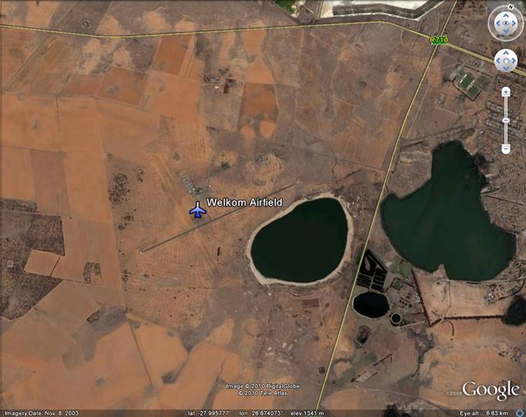
Airport is located next to
the Flamingo Pan, turnoff from the R30 Odendaalsrus -

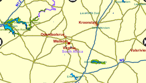
From JHB , take the N1 to
Kroonstad, then follow the R34 towards Welkom.
Then either go via
Odendaalsrus or Welkom to get to the R30.
Which involves lots of going around in circles.
If you go via the Welkom route, through the city, get out via Stateway or Long
Road until they intersect with the R30.
Turn towards
We meet under the shade under one of the trees next to the apron area.
Airspace
Info
Site Details
winch from
airfield.
One Airband radio required when winching takes place.
Welkom is 118.000 MHz airband required for winch operators
Got an E-W 2km runway and a N-S 1.5km dirt runway
no ceiling , 3000 m ATO in summer
Do not drive unnecessary on
the runways.
Before entering a runway or crossing it , stop , and check if there is no
aircraft taking off or landing.
For the North - South dirt
runway, go through the hangar area , and then onto the dirt runway.
Facilities might be locked.
Do not assume that the toilets are open.
Bring shade, water, cooldrinks.
Town center with shops is about 5-10 km away.
Closest garage for
pertrol and tyre punctures is 5km.
Beware of anthills on the
dirt runway.
Before the first launch on a weekend, run the full track and clear any anthills
and establish where to drive and where not.
For flying use 141.600.
141.625 got funny noise gadgets transmitting. Seems to be minining related.
Where to stay
Info
January 2004
Virginia Holiday resort
with big water slide at the river. Boat hire.
Tikwe Lodge 057 212 3306
Clives Place
Odendaalsrus
+- 16 km from Welkom
082 977 5344 or 057 398 2003
per Caravan R100 per
night, sleeps 4
Camping ( own tent )
R30
Chalets R110 per
person, or R150 per family+kids
Breakfast R30
Welkom Stanville
Inn 057 353 2482
Single room R150
Double room R180
Family room R200
Breakfast R30
Welkom
Hotel 057 355 1411
Signle/Double R258
Breakfast R40
Camping next to
Welkom Hotel R40
Welkom
Lodge 057 357 2291/2/3
Family room R150
Other rooms R150
Breakfast R35
Where to eat and
drink
Reastaurants
in the center of Welkom
What else to do
Flamingos
in the pan next to the airfield
Almanskraal game reserve
Virginia Holiday resort.
Hennenman gliding club.
100 km flight by Ulf 1 February 2004
109 km flight by Ulf
29/11/03
Saturday 29/11/03 at Welkom
Being a wind dummy
is a stressy job.
There we arrive at Welkom, winch is setup, and the question is who
is supposed to go first.
Everyone agrees it should be me.
Let's send up Ulf first. Let him check out what the conditions are
like.
And if he sinks out then he can wait until everyone else had his
turn.
Everyone gets one attempt, and then the next one gets a
chance.
So the
pressure is on. I better stay up if I want a decent flight. Or I can fly again
at sunset.
First
takeoff, 80m above the ground a loose loop falls off the drum and blocks.
I get catapulted, the left riser accelerator pully breaks,
the glider turns, and then the line breaks.
Next I
only see green stuff rushing towards me. The glider feels like it is still there.
No tendency to turn or spin. Just going dead
straight down towards the ground.
Similar to those fun fair rides when you come down the
looping star.
Then things settle down and I start seeing the horizon
and some sky again.
No collapses, no flops, no ruffles, rock solid wing
and we are back to normal flight 40 m
above the ground and then I land. Nice to fly a DHV 1 when
things go wrong.
The
accelerator is gone, no more speedbar can be used.
The
conditions look light. Not much wind. Lets go again. This time the winch launch
is less hectic.
Getting a thermal halfway down the runway, and it
takes me to 1700m AGL.
Very light drift towards Kroonstad.
15 minutes into flying the GPS 72 gives a battery low
warning.
I switch it off in case I need it later.
Lesson - Never use old alkaline rechargeables, which you
dumped out of your radio for your GPS.
The logger with the good old GPS 12 is in the
back pocket and will collect the flight.
So, no GPS, no groundspeed, and no speedbar. The gadget
flyer is back to nearly basics.
I radio through that I will head towards Kroonstad, in
case the radio also packs up.
Halfway to Kroonstad, at the top of a thermal hitting the inversion.
And I am listening now to the constant chatter
of the Senekal security services.
What is wrong with that radio now?
2000m high, gloves off, just do not loose them,
get that radio out.
Yes, the frequency is locked. But it is now on 145.000. How ??? No
idea.
How do you change this thing again?
Last done that some years ago.
Pressing buttons while body steering in the
inversion .
Bummer. now there is a T in the display and that
thing makes funny noises.
And now there is a big C where the frequency
used to be.
But there is nothing what a German Engineer can not
fix.
A few minutes later the display is back to 141.625 and
locked and ... why is this thing making
those diii -daaa - dooot - doot noises now.
Switch back on the 72 and get a quick position before
the battery goes dead.
50 km from takeoff on a bearing of 242, the
radio shows that I transmit ok, but those funny noises
make any reception a pain.
I switch off the radio. More back to
basics.
2 hours in the air, 70 km , 2500 m over the
Kroonstad Ultracity.
On the way to Welkom this morning we said this would
be the default goal for today.
Try to make it here.
But I am high, and there is still plenty of daylight
left.
I pick a road going to nowhere which is more or less
in the general drift direction.
80 km or 10 km past Kroonstad. Now what is this
brown curtain of dust doing there at the horizon?
Looks like a gustfront. Come on, be real, there are
hardly any clouds in the sky.
No overdevelopment. Must be some sort of big bushfire
creating all that haze.
90 km, that dust seems to come closer. Or maybe I get
closer to that big fire.
100 km there seems to be some more dust in front of
me, but hey, there is hardly any sink.
Must be some sort of convergence. But I do not
like that dust in the air further on.
In case this is some front I would like to be lower.
But the vario shows very light climb while
flying straight.
1500 m AGL says the Vario. Based on Welkom takeoff.
There is definitely dust getting kicked up about 10 km
ahead of me.
Get down now, fast, land, get out of the sky
now....
Find some open area in case you get
dragged.
In I go into a Spiral.
How high am I above the ground? No idea.
That alti info does not give me the height over
ground.
Fascinating, I managed to get the sink
indicator off the limits.
Wake up.
Rather look at the blur around you to take a guess
when to stop.
Otherwise you might miss your impact.
Those trees shooting past now look like big
trees , maybe time to stop this.
Out you go spiral.
That dust is maybe 5 km away. Tuck your
ears. Now what is that wind doing,
Perfect landing. No sign of that red dust. Very light breeze.
I can kick myself. Why did I land, there is nothing on the horizon.
The sky still looks perfect.
Could have still flown for an hour.
Oops those cows are coming towards you.
Rather bunch the glider and get away from the
cow inspection committee.
Kids from the township close by arrive.
where am I... , Edenville.
Give
some dust in the air.
Wait a minute there is some orange stuff now a few kms
away blowing towards us.
Time to pack up this canopy in a hurry, that wind is
picking up.
Glider is in the bag ... and here comes the dustfront.
50 km/h wind now.
Visibility down to a few meters
Bye everybody , I am off to towards the main
road and find the pub in Edenville.
From: "Westview
Lodge" <wes.tview.@global.co.za>
To: "Gauteng PG" <gauteng.pg.@smartgroups.com>
Sent:
Subject: [GautengPG] Welkom flying
Hi all
some of us went to welkom
for the w/e.
on saturday judy (bruce's
wife) was first in the air and got up in lightish
lift and flew into the welkom town (there are plenty of easy and friendly
landings there). bradley followed and got close to hennerman some 25 km
away, reporting a fairly good cloudbase, wind very light and in all
directions. Ulf got away on his second flight and also managed similar
distance. i had a line break on both of my flights, so preferred not to fly,
but rather do some recovery.
on sunday we had a fresh E
wind to start, becoming lighter at around
Ulf was first up and got winched to 700mt. I was second followed by bradley,
wind remained constant for most of the day at 20k/hr NE, becoming 9km/h
later, lift was inconsistent in strenght varying from light to moderate.
cloudcover became 3/8 in the early afternoon with a very short cloud cycle.
not knowing the area i aimed downwind towards bloem intially taking a
courageous direct route over farmland (there are some roads but going in a
90 degrees direction!) and only zig-zagging and following tarred roads later
to avoid long recoveries. I landed very close to Branfort, which is close to
the beginning of the bloem TMA. max height around 1500mt, distance 76km,
flight time
welkom is a nice site with
two good runways, one tarred, one not. the area
is user friendly because of a good network of roads in all direction.i woudl
definetely recommed it. thanks to bruce and judy for the hospitality.
clive
De Rust private nature
reserve.
By
invitation only.
Very good accommodation,
pool, pub, playground, ....
There are 8 chalets,
3 rondawels, 2 bunk rooms with about 20 beds and camping.
Usually it is
R180 (+40 pp) per chalet (Sleeps 4)
R100 (+30 pp) for rondawel (Sleeps 4, ablution block)
Bunker R40 pp, no linen
Attached the road map to De Rust private nature reserve.
Basically after Kroonstad one turns right to Welkom on the
R34. I think it is about 44km before you will see a huge
De Rust display board on your right at the turnoff onto a
dirt road. Just follow the directions. (Think it is 3km,
turn right and continue for another 6km.) Please be careful
just after the right turn; some cowboys have been humbled
in this area.
There are two toll gates on
the N1. (R9 & R28 ..think)
There is a nice bar, so dont
worry about drinks.
The chalets are self-catering.
October 2004 Jon Pio at 3500 m ATO