
A very basic, low level, introduction for a new proud owner of a GPS
who intends to use it for Hang Gliding and Paragliding.
The Earth is a sphere, something round like an orange or a
soccer
ball or your breakfast egg .
To define your position on that orange, mankind developed a coordinate
system based on North South East West.
Where the sun rises is East. Where the sun sets is West.
If you have the rising sun on your right , then your nose faces
North.
And opposite of North is South.
And then there is something called an equator which divides the
orange in the middle into a Northern and Southern Hemisphere.
The equator acts as one as the references for your position. The
equator
gets defined as 0 Degree for North or South Direction.
That 0 position we mark by pushing a stick from where you start
off
at the equator through to the center of the orange.
Lets travel North from your start at the equator for a while.
Stop and mark your position by pushing another stick
from where you are towards the center of the orange. The angle
between
the 2 sticks that intersect in the orange center is a value in degrees.
That value can be anything from 0 to 90 degrees.
If you go North, then you are x amount of Degrees North of the equator.
If you go South , then you are x amount degrees South of the equator.
North pole would be 90 degree North.
Now that we got N and S under control, we will have to sort
out
East and West.
For this one uses the Greenwich meridian, what is a line on the orange
which runs from the North Pole to the South Pole and goes through
Greenwich.
in the UK.
If you go towards the east of that line then you are x amount degrees
east of it. Up to 180. If you go further then you bump into degrees
that
come from the other side which are called x amount degrees West.
North and South values can go from 0 to 90 degrees. North values are
positive 0 to 90 or have a N for North. South values can be negative or
got a S for South.
East and West values can go from 0 to 180 degree. East are positive
0 to 180 or have an E for East. West values can be negative or W
marked.
See also
http://www-spof.gsfc.nasa.gov/stargaze/Slatlong.htm
From one degree to the next one is quite a big distance. To have
some
numbers in between, one uses minutes. 60 minutes make up one
degree.
And even minutes can be to big to define a position accurate, therefore
one uses seconds . 60 seconds make up one minute. Sounds familiar?
For South Africa, which is South of the equator ( why else would it be called South ?) and which is East of Greenwich , we got xx Degree South and y Degree East coordinates on a GPS. For example Cape Town is roughly ... or Johannesburg got ....
So, someone give his position in coordinates to you, get a map that
got those degree numbers on the sides and top and bottom.
A Maps with coordinates always got North facing to the top. So South
is at the bottom, towards you.
East is then at the right and west is at the left.
Back to locate that guy on the map. Take the South value, and find
the
values on the side of the map. Found it ? Mark it or put something
there.
Now go to the top of the map or to the bottom and find the East value.
Got it. From the East value got up or down and from the S value go
across
until the two meet. Bingo, got your persons location.
If you travel direct in N or S direction, not changing any East or West values, then 1 minute difference in position results in 1 Nautical Mile distance.
If you travel once around the Earth along the equator , then you cover about 40.000km. Or if you travel from the North Pole straight through Greenwich on that meridian until you hit the equator then you have done 10.000 km. 10.000 km to travel from 90 degree North (Pole) to 0 Degree at the Equator. 10.000km / 90 is something like 111 km. Each degree difference in North or South Direction ( and no change in East West ) is around 111 km.
1 minute corresponds to 1 NM. 60 minutes is one Degree. 1
Degree
corresponds to 60 Nautical Miles in North or South.
And 1 Degree is also 111 km. So we got 111 km which are 60
Nautical
Miles. 111km/60NM gives us 1.852 km per nautical
mile.
Or 1 minute coordinate difference in N or S is 1.852 km.
Another rule of thumb, nautical miles x 2 and then take 10
percent
off.
Example 6 nm , 6x2 = 12, 12 -
1.2 = 10.8 km
Why not in East West?
Only at the equator 1 minute will correspond to 1 nm for
East West.
Lets get your buddy to position himself at 0N 0E on the equator on
that Greenwich meridian. And you get yourself to 1 minute East of him
and
still on the equator.
You two are now 1.852km away from each other .
Both of you head straight North. With the same speed. And as
you go North you will come closer and closer. Until you meet at the
North
pole.
Remember , degrees, minutes, seconds give you a position on earth.
Not
a distance in relation to some other position.
If you want to get the distance between 2 positions , well that
can get complicated.
If it is straight in North South direction then it is straight forward.
If the East or West coordinates are the same, get the difference
in minutes between the North South Coordinates and those minutes are
the
same in Nautical Miles. Or multiply with 1.852
So what do I do if I have to find out what the distance is between any 2 points with whatever coordinates?
First option, read the manual of your GPS , and
it
will have an option there that will do it for you.
Second Option, in case you want to claim a distance world record,
go to the FAI website, Sporting Codes, Section 7
http://www.fai.org/documents/
and figure out the formula that FAI reckons one should
use in Chapter 14 of Section 7.
Third Option, which you anyway have to do for claiming a record, send your info to a local surveyor company who will give you a letter certifying the distance.
The frightening part is that none of those 3 options concur.
They
all differ by a few centimeters to meters.
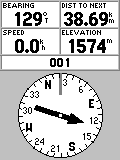
Report your bearing and the opposite site has to add/subtract 180
degrees
to get your location from their point of view.
Track changes all the time while you are flying. It is the direction
that you are flying at the moment.
In the example above the Pilot did Mark/Enter his Takeoff as 001. And set his GPS GOTO 001. Now he is on a BRG of 129 and 38.69 km away from 001 Takeoff. The recovery crew at Takeoff has to drive in a direction of 129 + 180 = 309 degrees to catch up with him. 309 is rougly in a NW direction.
Before you land in some bundu, desolate, desert,... fly briefly in
the direction towards wherever you plan to walk out, and note the track
reading. later on the ground, once packed up, and with no more visual
reference,
use that track reading and maintain it on your GPS while walking out
and
you should get closer towards the point you are aiming for.
During the Flight for the Plight of the Vulture Namibia I sank out short of Bitterwasser. Could see it clearly from the air. But once one the ground everything looked the same. There was no distinct feature that gave me some idea which way to go towards Bitterwasser. Had some idea what TRK to follow on the GPS . And then you march for about 30 minutes through the semi desert. And nothing changes. Well I got there to tell this tale. Once I got into the airconditioned pub and a German Weissbier watching the landscape through the big glass windows a sandstorm came through and reduced visibility for half an hour to a few meters.....
Did this article get you lost? Switch on your GPS and find out where you are....
-----Original Message-----
From: Keith Pickersgill [mailto:keith@xplorer.co.za]
Sent: 28 March 2004 13:39
To: capeflight@smartgroups.com; GautengPG List
Subject: [capeflight] Bernie and GPS confusion
James Braid wrote regarding Bernie's accident:
> A big problem experienced whilst trying to retrieve him was that
his
> gps was using UTM coordinates (that's what the Auzzies use) whilst
the
> comp was using the WGS84 format. So the coordinates that
he
was
> giving was far out from where he was. Very important lesson
to us
> all.
this is utter nonsense...
In the interests of safety, to avoid such future confusion, I
believe
it
is imperitive that everyone reads this to understand how GPS may create
this and other similar confusion, and how to completely overcome and
eliminate such confusion.
One day someone is going to die while waiting for rescuers, all
because
pilots are still confused about these issues. This brief explanation
below will clearly eliminate any such confusion.
If you own or use a GPS, you should print this out and read it
several
times until you understand this. Experiment on your GPS unit until
you
are totally familiar with these concepts.
UTM is a co-ordinate system, similar to (but different from)
Latitude
and Longitude. This is often called the "Location Format" or
"Grid
Sytem". There are dozens of different systems, the two most
widely
known (and used) are Latitude/Longitude, and UTM.
WGS84 is a datum, i.e. a mathematical equation describing the
curvature
of the surface of the Earth, and is NOT a co-ordinate system at all.
It
is used simply to improve accuracy, giving the GPS a very basic picture
of the shape of the planet (which is far from a perfect sphere).
When using a GPS, you need to choose both
(1) a co-ordinate system AND
(2) a Datum.
All GPS users, worldwide, should be using the WGS84 Datum, unless
they
have a very specific need to use an other Datum (extremely
rare!)
I guess what happened in the above story, is that Bernie was using
UTM
as a co-ordinate system, whereas everyone else was using standard
Latitude and Longitude. This would create a lot of confusion.
Another common cause of confusion with GPS users, is the
Latitude/Longitude format itself.
There are Three different versions; everyone should try to use the
same
version to avoid confusion.
These are usually denoted along the lines of: HDD MM SS.S or
similar,
to
describe which version a particular person or GPS unit is using.
Let me explain, and show where the confusion arises.
H = Hemisphere (N or S for Lat, and E or W for Long)
DD = Degrees of arc
MM = Minutes of arc
SS = Seconds of arc
The Three variations are:
1) HDD MM SS.S (Degrees, Minutes and Seconds)
2) HDD MM.M (Degrees and Minutes)
3) HDD.D (Degrees only)
(note: anything after a "Dot" denotes a fraction of that unit and
can
be
of any length of decimal digits)
Here are the Three different possibilities, using Dolphin Beach
location
as an example. Note all these are of the SAME location!!!
1) S33 49 33.2 E18 28 44.2
Format: HDD MM SS.S
i.e. South 33 Degrees, 49 Minutes, 33.2 Seconds
and East 18 Degrees, 28 Minutes, 44.2 Seconds
2) S33 49.553 E18 28.737
Format: HDD MM.M
i.e. South 33 Degrees, 49.553 Minutes
and East 18 Degrees, 28.737 Minutes
3) S33.82589 E18.47896
Format: HDD.D
i.e. South 33 Degrees and 0.82589 of a Degree
and East 18 Degrees and 0.4896 of a Degreee
Yes, all three are of the same position. just in a slightly
different
format!
Imagine if an injured pilot reads his position (Dolphin Beach above)
over the radio off his GPS which is set to the second version, but
the
rescuers have their GPS set to the first version.
The rescuers will mistakenly think he is at:
S33 Degrees 49 Minutes 55.3 Seconds
E18 Degrees 28 Minutes 7.37 Seconds
So they will be searching 1170 meters away from the actual accident
site. While they are running around the wrong field, the pilot may
die
from his injuries.
To avoid such confusion, most people use the Second version, i.e.
Format: HDD MM.MMM To be clear, this is Degrees, Minutes and fractions
of a minute. No seconds are used. This also happens to be the easiest
to
use on most maps, including the 1:50 000 scale Topographical charts
used
in PG/HG/PPG/ML comps
If everyone's GPS is set to the same system, there can never be any
confusion.
However, its quite easy to convert between the different formats. We
know that 30 seconds is half a minute, i.e. 0.5M and that 15 minutes
is
a quarter of a degree, i.e. 0.25D Likewise, 45 seconds is equivalent
to
0.0125 of a Degree.
Take the seconds, devide them by 60 to give you the fraction of a
minute
they represent. Likewise, the minutes devided by 60 gives you the
degree
fraction.
Lets take as an example, the above position's Latitude only
S33 49 33.2 (HDD MM SS) i.e. Degrees, Minutes and Seconds
To covert to H DD MM.MMM
33.2 decived by 60 = 0.553
Therefore S33 49.553 (Degrees, Minutes and fractions of
a minute)
Convert this to DD.DD:
49.553 devided by 60 = 0.82589
Therefore S33.82589 (degrees and fractions of a degree)
See how easy that is?
Regarding Datums:
If you have the wrong Datum selected on your GPS, you introduce a
possible error of only a few meters in most cases, not enough to thwart
a rescue search, so the Datum is not nearly as important as the Grid
System used.
However:
If, as in Bernie's case, the injured party is using UTM instead of
Lat/Long, the UTM grid format position would be: 34 H 266684 6254291
Imagine the confusing of a rescuer whose GPS is set to HDD MM.MM
How would he interpret the above position in order to locate the
pilot?
I can imagine the arguing and fighting taking place among the rescuers,
all trying to "convert" the above numbers to Lat/Long numbers, wasting
valuable time while the injured pilot slips into shock and eventually
might pass away while the rescuers are still arguing, or searching
in
the wrong location.
34 could be mistaken as S34 Latitude
but how to deal with the 6254291?
East 62 is not even in the same country!
They might argue that the dilerious pilot intended to say "East"
instead of "Six" I can imagine this argument might mosly likely
end up
in them searching at: S34 26.6684 E25 42.91 Which is 671 km from
the
correct location
To recap, each pilot should ensure their GPS is set as follows:
In the Field titled: "Grid" or "location Format" or "Co-Ordinate
System", select HDD MM.M (Note: they might have more than one
digit
after the decimal, its all the same)
In the Field titled:Datum, select WGS84
Whenever you give a position to anyone else over the radio,
telephone,
in person or in writing, ensure you mention this is Degrees and Minutes
with fractions of a minute, and not Seconds!
This will avoid any confusion and may well save someone's life someday!
---------------------------------------------------
Keith Pickersgill, Xplorer UltraFlight
Performance Paramotors for Powered Paragliding
PO Box 36784, Chempet, 7442
Cape Town, South Africa.
Tel /Fax: +27(0)21 558-7231
Mobile 082-414-8448
email: keith@xplorer.co.za
Web: http://www.xplorer.co.za