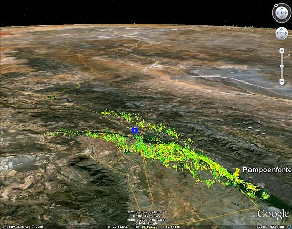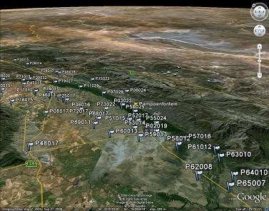
Thermal collection, kmz files

One has to first check with the local pilots if it is ok to use it. It has a much longer recovery compared to Dasklip takeoff.
James Braid flying Eselsfontein backwards, 6.2MB .mov Real Player
Google Earth kmz file for Pampoenfontein

2009 Winelands turnpoints in csv and as kmz
Google Earth kmz file
Rob
~~~~~~~~~~~~~~~~~~~~~~
Airborne Paragliding
PO Box 400
PORTERVILLE 6810
South Africa
+27 22 931 3416 (Janine)
+27 83 267 5657 (Bradley)
+27 82 788 4398 (Rob)
<airborne at telkomsa dot net>
<www.porterville.co.za>
~~~~~~~~~~~~~~~~~~~~~~
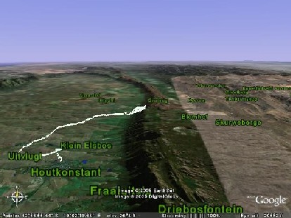
Flight from Dasklip Launch to Flyers Lodge , http://earth.google.com KMZ File created with TP

Located in the Western Cape
About 200 km North of Cape Town


In case Dasklip is not flyable and you still want to get into the air, check with the locals.
Lions Head might be an option in Cape Town, will take you 2-3 hours to get there.
Haystek is another site, but will take about 2-3 hours to get to takeoff.
SLP, Sir Lowrys Pass, maybe 2-3 hours
Hermanus 3-4 hours to get there.
___________________________________
Cape Town +27 21 434 2011
Fax +27 21 418 6000
Porterville +27 22 931 3416 Fax/answer-phone
(Marijke)
Mobile +27 83 267 5657 (Bradley)
Mobile +27 82 442 2710 (Vossie)
Mobile +27 82
788 4398 (Rob)
From: "Jaco Wolmarans" <jaco@wordsource.co.za>
To: <capeflight@smartgroups.com>
Sent: Monday, March 01, 2004 2:13 PM
Subject: [capeflight] Saturday at Porterville
> So there I was, getting airborne and not really feeling like it. My
back
was
> hideously sore from compensating for a cricked neck muscle on Friday,
I'd
> slept badly and the air was obviously rough. I watched Gaynor come
past
> from Pampoenfontein, hit a marlin strike to the right of launch,
and her
Jazz
> pitch back. Hoohaa, this was going to be fun.
>
> Angelo, Ioel and the boys had disappeared down the ridge, while Danny
> was hanging back. I launched soon after him. Danny went straight
for the
> Tierkloof dam and spent 20 minutes at almost the exact same altitude
just
> above the tree line in what must rank as some of the most tenacious
flying
I
> have ever seen. But alas, before he could give up, earth came up
to meet
> him just beyond Tierkloof.
>
> Angelo and Gary V had since landed not far from there. The air was
> unreasonably rough, the thermals small and nigh unworkable if you
got
> yourself low down. Even if you connected them high up, they remain
crappy
> all the way to 1400 ASL, where I twice left the climb in disgust
to go and
> sort out my ruffled tail feathers.
>
> I followed my usual route, but confused Danny by flying a white Jumbe
this
> time. He thought the red glider hugging the ridge next to me was
'ol
> Stoffpad sneaking in a ridge flight while no-one was looking. I had
to put
the
> records straight, and headed out into the flats, aiming for Eendekuil.
Gary V
> kindly drove my bakkie down and Danny took over the driving, sweeping
the
> dust road for a heap of pilots who had given up/got forced down.
>
> It was strange to watch - virtually everyone on the ridge could not
quite
get
> higher than 50m or above the top, and in the flats, climbs were
accellarating
> at this altitude. I had a feeling that a mass of SW air was already
starting to
> mix with the NW forecast for later, but that because the SW was stronger,
it
> was pushing back the incoming wind. Guess who found himself at the
> coalface of these two masses all the time.
>
> Because of my lethargic state I got a quick wake-up call early on
in the
flight
> which made me realise again that if you want to fly XC you can't
sit and
> contemplate your navel. It takes concentration, so either you sharpen
up
or
> go land. Well, when I decided I'd rather go land, I was rather high,
and
> when I wanted to carry on, I was hunting desperately low.
>
> But the gods saved me and trigger point after trigger point delivered.
The
> climbs were rough but solid, and they were not too far apart. The
sink,
> however, was insane, so it was a toss-up all the time to carry on
towards
the
> ridge in a thermal, or to punch out and leave the thermal when you
got
> halfway across the dirt road towards the mountain.
>
> I tried keeping a manageable vector towards Eendekuil, and tried
> desperately not to go too close to Bumpy, from where the flight out
across
> the no-mansland is usually a bit of a nightmare because of the into-wind
> component being greater if you try to leave from there. Nevertheless,
in
no
> time at all I found myself close to Bumpy, too close, in fact, as
I had
feared.
>
> But I was climbing well and even had time to compose a song: (ahem
- sing
> along to the tune of Yesterday by The Beatles) "Yesterday, Bumpy
always
> seemed so far away ..."
>
> Singing helped take my mind off the slaps I was getting but did not
land
me
> a stint at Coca Cola Popstars, so off I went in search of XC glory
rather,
> taking a bold glide straight across the Pietersklip turnoff, over
the big
crop
> circles, directly to Eendekuil and a (alarmingly) few triggers inbetween.
>
> Sink. Heaps of it. Then trigger point one. Nothing. Change course
slightly -
> a piece of vaguely green field (the colour difference, I hoped would
produce
> the goods). Nothing. One chance left, 170 AGL - a triangular field
of
fynbos
> on the downwind side of a slight depression. Yes, I was low enough
to see
it
> was a depression. And it was #@**&^ miles away from anything
remotely
> resembling shade. Me and my (**&^% theories! Suffer, baby.
>
> Flying over le patch, it triggered violently. I held on, flying straight
downwind
> and keeping the Jumbe reigned in. It was huge, at least 7 seconds'
worth
of
> lift, and at the end I turned sharply and faced back into wind, just
in
time to
> hear Danny call that there are heaps of whirlies about and I should
be
> careful. Ja right. Thanks for sharing that at this exact moment.
>
> Fling her about again, race downwind, and then I'm hooked into the
most
> solid climb of the day, averaging 3.5m/s without touching sides.
What a
> pleasure! Jumbe wingtip down, the harness creaks with the accelaration.
I
> grab the speaker mike to answer Danny who was asking if I'm still
flying.
> Yes, I brag, xxx m/s second up, dude! Careful, he says. Whirlies
thick and
> fast now.
>
> Whack! Not concentrating, I fly too far downwind in the thermal and
exit
it
> not too gracefully. It's OK, it's so far into the flatlands no-one
would
have
> seen that (-:
>
> This thermal takes me back to 1000m over ground, and I'm confident
to
> make Eendekuil on straight downwind glide. I inform Danny, he collects
the
> stragglers on the road and heads out to the N7.
>
> I'm still following a cloud formation which I suspect is part of
the
> convergence line when I hit the NW. And from gliding comfortably
to
> Eendekuil I glide, but only just, to the N7. As I arrive, I pick
up
another
> thermal, but Danny's whirly warnings are now as frequently as the
slaps in
> the air, so I fly through it and spiral down in the sink. Even so,
I have
a
> couple of interesting moments.
>
> The surprising thing about this convergence line as that at the interface,
> there seems to be no wind on the ground. And as Dirk has frequently
> pointed out, this usually occurs around the N7, where you meet this
still,
hot
> section with no sign of wind except these strange columns of air
taking
lots
> of agricultural soil up with them.
>
> Lesson learnt: when approaching for a landing around midday and you
> cannot see any wind around, be aware that you might be entering troll
city.
>