 FAD are Danger Areas.
One can fly in there. But you might encouter , for example,some
planes doing aerobatics.
as Ulf Arndt understands it in 2005
The air around us is split up into either controlled or uncontrolled
air space.
Controlled airspace means, that an air traffic controller routes all
the planes flying in it and keeps them apart.
What is based on the assumption that everyone flying in controlled
airspace is in radio communication with this air traffic controller.
And can be seen on the radar screen. The pilots flying in controlled
airspace do not look outside and rely on the air traffic controller to
guide them.
They do not expect any other planes around them. And they fly by Instruments
telling them where they are.
Uncontrolled airspace relies on VFR Visual Flight Rules, assuming that every pilot looks outside and makes sure that we do not fly into each other.
Since Paragliders and Hang Gliders have not got airband radios, do not reflect radar and fly without radar transponders... means we are expected to stay outside of controlled airspace. Otherwise we endanger the other airplanes. Who fly on IFR, Instrument Flight Rules. And a pilot of a plane that is leaving or approaching an airport is very busy going through checklists and reconfiguring the plane and has no time to look outside. Those big planes are also so lame that they can not avoid any obstacle that suddenly gets into a collision course with them.
So, in a nutshell, stay in uncontrolled airspace and fly within VFR
conditions. VFR conditions are 8 km visibility and clear of cloud and you
have to see the ground.
And during day light. Flying at night is not allowed.
Now, where do I find out where these controlled and uncontrolled
airspace are?
One has to obtain a recent airspace map, also called ICAO maps.
Here are some examples of what info they provide that is relevant for us.
 FAD are Danger Areas.
One can fly in there. But you might encouter , for example,some
planes doing aerobatics.


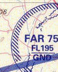 FAR are Restricted
Areas. One can not just fly into them. First one has to find out under
what conditions you can enter them, if at all.
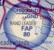 FAP are Prohibited Areas. No
go, No fly zones. Do not fly into them.
  Those ones go from the Ground GND up to a certain altitude , like 1000
ft ALT , or 300 meters above ground
Control Zones (CTR)
![]() A CTR is a Controlled
Airspace around an airport. You can not enter into it unless you got radio
contact with the tower and permission by the tower to fly in it.
A CTR is a Controlled
Airspace around an airport. You can not enter into it unless you got radio
contact with the tower and permission by the tower to fly in it.
Terminal Manoeuvre Areas (TMA)
A TMA is also a Controlled Airspace on top and around a major airport. 
This one for example means That it starts at 7600 feet ALTitude from
sea level and goes up to Flight Level 110 = 11000 feet.
Class C means in dummy terms, that it is not for airplanes who fly
only visual. 3 feet is roughly 1 meter. So that airspace starts from
2300 m above sea level.
We can fly under it between the ground , which is around 1600m. So,
if we zero our altimeter on takeoff in the JHB area we can maximum go 700
meters high.
Without getting in the way of the big birds.
 Altitude on the maps are
in feet. 1 meter is 3.2808 feet. Divide by 3 or multiply
by 3 and then divide by 10.
 NDB
NDB 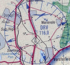 and VOR , radio beacons
for the planes who navigate by instruments
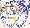
Unimportant for us, but one can expect more powerplane traffic around
them. They make it easy for them to navigate. The bigger a plane the more
they just fly from one to the next one.
And those pilots might not be looking outside.
Example of an airway
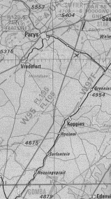
This airway starts at FL105 and goes up to FL 195. With the ground around 5000 ft, one has got 10500 - 5000 = 5500 ft above ground.
5500ft / 3 is a little bit more than 1800 m AGL.
http://www.flytandem.com/airspace.htm
The AIP Info for flexible airspace around Gariep - Bloemfontein
National Airspace Master Plan in pdf
Q codes http://www.fact-index.com/q/qn/qnh.html
How to talk the talk http://www.caa.co.za/resource%20center/licensing%20&%20exams/examdocs/Aviation%20RT%20Base%20Operator%20Study%20Manual.htm
More info on Paragliding in South Africa at http://www.funwings.com