
Created Wed May 17 20:31:43 CAT 2006
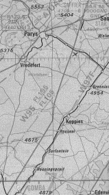
| How high is this takeoff? | |||
|
|||
| a | 5249 meter | ||
| b | 2916 meter | ||
| c | 1600 meter | ||
| d | can not be determined, this is a beacon reference number | ||
Correct Answer ..... c
| What does this map snippet describe | |||
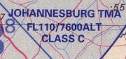 |
|||
| a | We can not fly above 110 feet above ground | ||
| b | We can fly up to FL110 = 11000 feet | ||
| c | We can not fly above 2300m above sea level | ||
| d | Class C stands for Common usage, everyone can use it | ||
Correct Answer ..... c
| Which statements are true in using a GPS | |||
| a | One can collect Waypoints by MARK/ENTER | ||
| b | One can download Waypoints to a PC via a datacable | ||
| c | A GPS can collect track points | ||
| d | Your track memory fill rate depends on the sample rate setting | ||
| e | The only way to collect coordinates of a Waypoint is to write them down on paper | ||
| f | One can download track points to a PC via a datacable | ||
| g | Your track memory fill rate depends on the amount of turnpoints of the task | ||
Correct Answer ..... a b c d f
| A Hang Glider is climbing towards you in a thermal, turning the opposite direction | |||
| a | Since you established the thermal first you determined the thermal direction. He will change turn direction when he gets closer | ||
| b | Hang Gliders have to give way to Paragliders. He will look out for you | ||
| c | You are above him and he can not see you. Change turn direction and get out of the way | ||
| d | The stronger lift will soon catch up with you and you will also climb better | ||
Correct Answer ..... c
| Flying under the JHB Special Rules area at The Dam or Dunnottar | |||
| a | One has to 0 your altimeter on takeoff | ||
| b | One has to fly QFE | ||
| c | One has to use the QNH of JHB International | ||
| d | One has to use 1013 hPa setting | ||
Correct Answer ..... c
| Since we are allowed to fly only in VFR conditions which means ... | |||
| a | fly during daylight only | ||
| b | from FL100 to FL200 minimum visibility 8 km | ||
| c | stay clear of cloud, from FL100 to FL200 Horizontally: 1.5 km, Vertically: 1000 feet | ||
| d | up to FL100 minimum visibility 5 km | ||
| e | VFR does not apply for Hang Gliding or Paragliding | ||
| f | stay clear of cloud, up to FL100 Horizontally: 2000 feet, Vertically: 500 feet | ||
Correct Answer ..... a b c d f
| At noon the sun is located in South Africa in the | |||
| a | South | ||
| b | East | ||
| c | North | ||
| d | West | ||
Correct Answer ..... c
| What does the expression AGL mean ... | |||
| a | AGL = Aerodrome Ground Level | ||
| b | AGL = Above Glider Launch | ||
| c | AGL = Above Ground Level | ||
| d | AGL = Aircraft Ground Landing | ||
Correct Answer ..... c
| The task uses 400m cylinders. How big do you set you GPS 12 zoom display to see the inner circle as the tunrpoint cylinder? | |||
| a | 1.2 km | ||
| b | 4 km | ||
| c | 0.4 km | ||
| d | 2 km | ||
Correct Answer ..... d
| Flying trimspeed into wind your GPS shows 16 km/h and when you turn downwind you got 60 km/h | |||
| a | Your trmi speed is 36 km/h | ||
| b | One can not determine the trim speed with this info | ||
| c | Your trim speed is 34 km/h | ||
| d | Your trim speed is 38 km/h | ||
Correct Answer ..... d
| What is Class G Airspace ? | |||
| a | airspace in which IFR flights and VFR flights are permitted and all such flights receive flight information services, if requested. | ||
| b | airspace in which only IFR flights are permitted and all such flights are - (i) subject to air traffic control services; and (ii) separated from each other; | ||
| c | airspace in which IFR flights and VFR flights are permitted and - (i) all such flights are subject to air traffic control services; (ii) IFR flights are separated from each other and receive traffic information in respect of VFR flights; and (iii) VFR flights receive traffic information in respect of all other IFR flights and VFR flights; | ||
| d | airspace in which IFR flights and VFR flights are permitted and - (i) all such flights are subject to air traffic control services; (ii) IFR flights are separated from each other and from VFR flights; and (iii) VFR flights are separated from IFR flights and receive traffic information in respect of all other VFR flights; | ||
Correct Answer ..... a
| Santa performs a touch and go on the top of Ben Nevis, zeroing his altimeter in the process... ? | |||
 |
|||
| a | he will be using QNH | ||
| b | he is flying based on Standard Atmosphere | ||
| c | he is on 1013mb | ||
| d | he will be flying QFE | ||
Correct Answer ..... d
| Looking from takeoff down towards turkey. The sun is in front of you. It is 11.40. Which way are you facing? | |||
| a | One requires a GPS to determine this | ||
| b | East | ||
| c | South | ||
| d | One requires a compass to determine this | ||
| e | West | ||
| f | North | ||
Correct Answer ..... f
| why is it important that all aircraft under the Johannesburg TMA fly on the same QNH ? | |||
| a | All pilots talk on the same frequency | ||
| b | Wrong, all pilots must use QFE under the JHB TMA | ||
| c | All pilots fly under the same IFR conditions | ||
| d | all pilots fly based on the same altitude reference | ||
Correct Answer ..... d
| What does the expression GND mean ... | |||
| a | GND = Glide Normal Distance | ||
| b | GND = Global Navigation Device | ||
| c | GND = General Navigation Device | ||
| d | GND = Ground | ||
Correct Answer ..... d
| Ceiling is 7600 ft. | |||
| a | This corresponds to 2300m AGL. 7600 /3 | ||
| b | This corresponds to 1400m ASL. ((7600/10)*2)-10 percent | ||
| c | This correponds to 1400m AGL. ((7600/10)*2)- 10 percent | ||
| d | This corresponds to 2300m ASL. 7600/3 | ||
Correct Answer ..... d
| Dusk Dnd dawn are longer | |||
| a | as one goes further North in South Africa | ||
| b | in summer | ||
| c | in winter | ||
| d | as one goes further South in South Africa | ||
Correct Answer ..... d
| You plan to winch off the XYZ airfield. The main tar runway says 07 at one end. The wind is Westerly. The field got a grass runway on an angle of 100 degree to the main runway. What will you announce on the airband radio when you launch a paraglider, using the most suitable runway into wind? | |||
| a | XYZ Traffic, Paraglider winchlaunched on 33 tar runway | ||
| b | XYZ Traffic, Paraglider winchlaunched on 33 tar runway | ||
| c | XYZ Traffic, Paraglider winchlaunched on 17 grass runway | ||
| d | XYZ Traffic, Paraglider winchlaunched on 25 grass runway | ||
| e | XYZ Traffic, Paraglider winchlaunched on 25 tar runway | ||
| f | XYZ Traffic, Paraglider winchlaunched on 07 tar runway | ||
| g | XYZ Traffic, Paraglider winchlaunched on 32 grass runway | ||
| h | XYZ Traffic, Paraglider winchlaunched on 33 grass runway | ||
| i | XYZ Traffic, Paraglider winchlaunched on 15 grass runway | ||
Correct Answer ..... e
| The Sun sets in the | |||
| a | East | ||
| b | North | ||
| c | South | ||
| d | West | ||
Correct Answer ..... d
| Here is a polar diagram comparing a Beginner and a Competition wing. It shows the speed to fly for a 2 m/s average day, and 20 km/h wind pushing you. On a 5 hour flying day, assuming both pilots fly optimal, how far will each pilot have gone? | |||
 |
|||
| a | Beginner 200 km, Competition 230 km | ||
| b | Beginner 205 km, Competition 185 km | ||
| c | Beginner 185 km, Competition 205 km | ||
| d | Beginner 305 km, Competition 335 km | ||
Correct Answer ..... c
| Where is the pilot in relation to 001 ? | |||
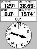 |
|||
| a | SE | ||
| b | W | ||
| c | NW | ||
| d | E | ||
Correct Answer ..... c
| The wind is around 18 km/h. The smoke is going up under a 45 degree angle. And your Glider will have a 2 m/s polar sink rate to turn in that thermal. What lift will your vario show when you get into the smoke? | |||
| a | 4 m/s | ||
| b | 1 m/s | ||
| c | 5 m/s | ||
| d | 3 m/s | ||
| e | 2 m/s | ||
Correct Answer ..... d
| FL195 means ... | |||
| a | Forward Launch only take off, 195 meters wide | ||
| b | The maximum one can go up in SA in a Paraglider outside of any other airspace restrictions | ||
| c | Flight Level 195, 19500 meters ASL | ||
| d | Flight Level 195, 19500 feet AGL, or around 6200 meters above ground | ||
| e | Flight Level 195, 19500 feet ASL, or around 6200 meters | ||
| f | Foot Launch takeoff, 195 meters high | ||
Correct Answer ..... b e
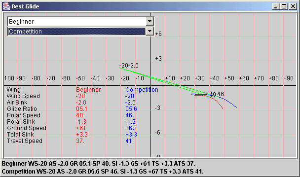
| In this polar diagram comparing a Beginner and a Competition wing. It shows the wings in 2m/s sink and 20 km/h wind pushing you. How fast, based on your air speed indicator, should the pilots travel to fly optimal? | |||
 |
|||
| a | Beginner 40 km/h, Competition 46 km/h | ||
| b | Beginner 57 km/h, Competition 61 km/h | ||
| c | Beginner 61 km/h, Competition 67 km/h | ||
| d | Beginner 37 km/h, Competition 41 km/h | ||
Correct Answer ..... a
| What does this picture mean ... | |||
 |
|||
| a | Do not fly into it | ||
| b | It is a Notam | ||
| c | This applies from Ground to 2300 meters ASL | ||
| d | It is a Federal Air Defense area | ||
Correct Answer ..... c
| In South Africa in Winter the Sun at noon is located | |||
| a | In the South | ||
| b | In the East | ||
| c | In the North | ||
| d | In the West | ||
Correct Answer ..... c
| What does the expression ft mean ... | |||
| a | ft = feet, 3 meters is approximately 1 feet | ||
| b | ft = foot takeoff | ||
| c | ft = feet, 3 feet is approximately 1 meter | ||
| d | ft = final track, your heading before you flare | ||
Correct Answer ..... c
| What is the name of the unit used in aviation which has a value of 1.852 km/h | |||
| a | one nautical mile | ||
| b | one degree | ||
| c | one knot | ||
| d | one foot | ||
Correct Answer ..... c
| 100 years ago, the Wright brothers were towing their contraptions airborne before they succeeded in using petrol engines. They used an ingenious 2-pulley system as illustrated. The tow rope is attached to the car, then routed through pulley B which is anchored to the ground, then back to pulley A on the car, then all the way to the Flyer. After an aborted launch, Orville drags his Flyer back to the launch point, also pulling both rope and car in the process. Wilbur observes 100 yards of rope coming through pulley A. How many yards has Orville moved the Flyer back ? | |||
 |
|||
| a | 100 yards | ||
| b | 50 yards | ||
| c | 150 yards | ||
| d | 200 yards | ||
Correct Answer ..... c
| A TMA is labeled FL110 / 4500 ALT .. | |||
| a | Controlled airspace starting from 4500m ASL to 110 km | ||
| b | Low flying Temporary Military Aviation activity, starts every day at 11.00, up to 4500 ft | ||
| c | Controlled airspace from 1500m ASL to 3300m ASL | ||
| d | Temporary Closed area from day 110 of the year above 4500m altitude | ||
Correct Answer ..... c
| As Santa flies level with Mont Blanc, he sets his altimeter to display 4807m, Europe's highest peak... ? | |||
 |
|||
| a | he will be using QNH | ||
| b | he is flying based on Standard Atmosphere | ||
| c | he will be flying QFE | ||
| d | he is on 1013mb | ||
Correct Answer ..... a
| What does this picture mean ... | |||
 |
|||
| a | This is a VOR | ||
| b | It is a Danger Area | ||
| c | This is a NDB | ||
| d | It is a Parachute Drop Zone | ||
Correct Answer ..... c
| A pilot has reported his position as 9km from takeoff on a bearing of 330. You are 10 km from takeoff on a bearing of 330 | |||
| a | The pilot is SW of you | ||
| b | The pilot is NE of you | ||
| c | The pilot is Nw of you | ||
| d | The pilot is SE of you | ||
Correct Answer ..... c
| VFR | |||
| a | Does not apply for Hang Gliding and Paragliding | ||
| b | stands for Vee Follow Railway - a way of navigation before GPS was around | ||
| c | means Visual Flight Rules and applies to Hang Gliders and Paragliders | ||
| d | means 8 km visibility, not flying into cloud, not flying at night | ||
Correct Answer ..... c d
| If a ridge is 200 meters high, how far behind can you land safely and why ? | |||
| a | 4 km | ||
| b | due to whirlys which kick off in the windshadow | ||
| c | due to wind shadow behind the ridge resulting in no airspeed for the glider | ||
| d | 200 meters | ||
| e | 1 km | ||
| f | 2 km | ||
| g | due to Rotor and turbulence in the lee | ||
| h | due to katabatic airflow which runs down the slope | ||
Correct Answer ..... f g
| What does the expression NM mean ... | |||
| a | NM = Navigation Manager | ||
| b | NM = Normal Mile, 1.6 km | ||
| c | NM = Nautical Mile , 1.8 km | ||
| d | NM = Nautical Manager | ||
Correct Answer ..... c
| What does this picture mean ... | |||
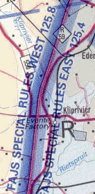 |
|||
| a | Do not fly into it unless you contact the tower on 125.4MHz | ||
| b | West starts from FL 125 down to FL 8 | ||
| c | Use 125.4 MHz airband radio frequency when East of this line | ||
| d | East starts from FL 125, down to FL4 | ||
Correct Answer ..... c
| If you can hear thunder while flying ... | |||
| a | means you are in trouble, get down and land, fast | ||
| b | can be ignored | ||
| c | means it is 16km or less away | ||
| d | means to head towards it to find good lift | ||
Correct Answer ..... a c
| The highest one can go in a HG or PG outside of any other airspace restrictions | |||
| a | FL195, 19500m ASL | ||
| b | FL100, 10000m ASL | ||
| c | FL195, 19500ft, 5900 m ASL | ||
| d | FL100 , 3300m ASL | ||
Correct Answer ..... c
| Flying XC from Welkom in a NE wind. How high can you be over Petrusburg, assuming that Petrusburg got the same height as Welkom of about 1400 m ASL. | |||
 |
|||
| a | about 4400 meters above sea level | ||
| b | Not allowed to ebter the airspace over Petrusburg | ||
| c | about 3000 meters above takeoff | ||
| d | 14500 feet above sea level | ||
Correct Answer ..... a c d
| What does this picture mean ... | |||
 |
|||
| a | This is a CTR for winch launch activity | ||
| b | It is a NDB | ||
| c | This shows a VOR | ||
| d | Contact the tower at 116.0 MHz | ||
Correct Answer ..... c
| What does the expression ASL or AMSL mean ... | |||
| a | ASL = Above Surface Level | ||
| b | AMSL = Above Mean Surface Level | ||
| c | ASL = Above Sea Level | ||
| d | AMSL = Above Mean Sea Level | ||
Correct Answer ..... c d
| Which statement is true | |||
| a | Sunrise is earlier in Summer | ||
| b | Sunrise is later in Summer | ||
| c | Sunset is later in Summer | ||
| d | Sunset is earlier in Summer | ||
Correct Answer ..... a c
| Lunch time in the center of South Africa and you shadow on the ground is in front of you | |||
| a | you are facing North | ||
| b | you are facing west | ||
| c | you are facing South | ||
| d | it depends on the wind direction | ||
Correct Answer ..... c
| South Africa is located | |||
| a | in the Northern Hemisphere | ||
| b | in the NATO | ||
| c | in the Southern Hemisphere | ||
| d | in the Eastern Block | ||
Correct Answer ..... c
| To calculate the distance for a world record one uses | |||
| a | a Great Circle Distance formula from SAHPA | ||
| b | the GAP Formula | ||
| c | the Bernoulli equation | ||
| d | a Great Circle Distance formula from FAI | ||
| e | Daltons law | ||
Correct Answer ..... d
| On an Airspace map an FAR means | |||
| a | A Prohibited Area, you can not enter into that airspace at all | ||
| b | A Defense Force Area, you will be used for shooting practice if you fly there | ||
| c | A Danger area, you can fly there, but certain activity, like aerobatics can happen | ||
| d | A Restricted Area, better stay out of it | ||
Correct Answer ..... d
| What does the expression Ceiling mean on an ICAO map ... | |||
| a | Ceiling = Another word for cloudbase | ||
| b | Ceiling = Maximum height to go over a goal line | ||
| c | Ceiling = Maximum height before we go into Controlled Airspace | ||
| d | Ceiling = The top of the inversion layer | ||
Correct Answer ..... c
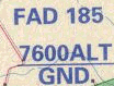
| On an Airspace map an FAD means | |||
| a | A Prohibited Area, you can not enter into that airspace at all | ||
| b | A Defense Force Area, you will be used for shooting practice if you fly there | ||
| c | A Danger area, you can fly there, but certain activity, like aerobatics can happen | ||
| d | A Restricted Area, better stay out of it | ||
Correct Answer ..... c
| What is the lower limit of a CTR | |||
| a | it joins the CTA around it | ||
| b | it joins the TMA around it | ||
| c | 1000 ft | ||
| d | ground level | ||
| e | 300 meter AGL | ||
Correct Answer ..... d
| Which airspace starts on the ground | |||
| a | TMA | ||
| b | CTA | ||
| c | CTR | ||
| d | ATZ | ||
Correct Answer ..... c
| A pilot has set his GPS to GOTO TAKEOFF and reports his position on a Bearing BRG of 90 | |||
| a | He is to the East of takeoff | ||
| b | He is flying in a Westerly direction and can be anywhere | ||
| c | He is to the West of takeoff | ||
| d | He is flying in an easterly direction, could be anywhere | ||
Correct Answer ..... c
| While flying cross country, what do you look out for | |||
| a | Smoke, flags, | ||
| b | shadow of you glider on the ground | ||
| c | cloud shapes, if any, and how they develop | ||
| d | speed of your glider in comparison to speed of the cars on the ground | ||
| e | Possible landing places | ||
| f | Wind drift | ||
| g | cloud shadow movement on the ground | ||
| h | the way cows are grazing on the ground | ||
| i | battery charge status on your radio and cell phone | ||
Correct Answer ..... a c e f g
| There are few airliners flying on Christmas Eve, but Santa listens to all Air Traffic Controls to avoid them, not wanting to be spotted... ? | |||
 |
|||
| a | he will be using QNH | ||
| b | he is flying based on Standard Atmosphere | ||
| c | he will be flying QFE | ||
| d | he is on QFA | ||
Correct Answer ..... b
| South Africa is located | |||
| a | about 30 degree West of the Greenwich meridian | ||
| b | about 30 degree North of the Greenwich meridian | ||
| c | about 30 degree East of the Greenwich meridian | ||
| d | about 30 degree South of the Greenwich meridian | ||
Correct Answer ..... c
| When can you fly into a CTR | |||
| a | when I get permission by the tower | ||
| b | always | ||
| c | when it is not active | ||
| d | only on weekends and public holidays | ||
Correct Answer ..... a
| The sun in Southern Africa will everywhere be | |||
| a | in the South | ||
| b | mostly in the South, but in summer noon South of Limpopo it can be in the North | ||
| c | in the North | ||
| d | mostly in the North, but in summer noon North of Limpopo it can be in the South | ||
Correct Answer ..... d
| If you head 1.852 km straight East from your current position of S28 degree 30 minutes East | |||
| a | Can not be that easily determined without a map at hand | ||
| b | you will be at 28 degree 28.148 minutes East | ||
| c | you will be at 28 degree 31.852 minutes East | ||
| d | you will be at 28 degree 31 minutes East | ||
| e | you will be at 28 degree 29 minutes East | ||
Correct Answer ..... a
| 100 years ago, the Wright brothers were towing their contraptions airborne before they succeeded in using petrol engines. They used an ingenious 2-pulley system as illustrated. The tow rope is attached to the car, then routed through pulley B which is anchored to the ground, then back to pulley A on the car, then all the way to the Flyer. Q 1. With Orville on board, the minimum take off speed of the Flyer is 40mph. In a 10mph headwind, at what minimum speed should Wilbur drive to launch his brother? | |||
|
|||
| a | 5mph | ||
| b | 20mph | ||
| c | 10mph | ||
| d | 15mph | ||
Correct Answer ..... c
| Flying XC over flatlands, 80 km from takeoff, 2400 m AGL, 17.00, not expecting any thermal activity anymore. Groundspeed is 60 km/h. Average sink is 2m/s. How far will you get and when will you land? | |||
| a | 110 km | ||
| b | 120 km | ||
| c | land 17.40 | ||
| d | not enough info to answer this question | ||
| e | 100 km | ||
| f | land at 17.20 | ||
| g | land 17.10 | ||
| h | land 17.30 | ||
| i | 90 km | ||
Correct Answer ..... e f
| In this polar diagram comparing a Beginner and a Competition wing. It shows the wings in 2m/s sink and 20 km/h wind pushing you. What should your GPS speed show, to fly optimal? | |||
 |
|||
| a | Beginner 40 km/h, Competition 46 km/h | ||
| b | Beginner 57 km/h, Competition 61 km/h | ||
| c | Beginner 61 km/h, Competition 67 km/h | ||
| d | Beginner 37 km/h, Competition 41 km/h | ||
Correct Answer ..... c
| If you head 1.852 km straight North from S26 degree 30 minutes | |||
| a | Can not be that easily determined without a map at hand | ||
| b | you will be at 26 degree 28.148 minutes South | ||
| c | you will be at 26 degree 31.852 minutes South | ||
| d | you will be at 26 degree 31 minutes South | ||
| e | you will be at 26 degree 29 minutes South | ||
Correct Answer ..... e
| What does the expression VFR mean ... | |||
| a | VFR = Vee Follow Railway | ||
| b | VFR = Virtual Flying Rules | ||
| c | VFR = Visual Flight Rules | ||
| d | VFR = Very Fast Reserve | ||
Correct Answer ..... c
| A pilot SMS his landing coords as S 26 28.506 E 028 38.025. The recovery types in S 26 28.506 E 028 30.025. Where is the recovery going to look for the pilot? | |||
| a | about 8km West of the pilot | ||
| b | about 8 km East of the pilot | ||
| c | about 14 km West of the pilot | ||
| d | about 14 km East of the pilot | ||
Correct Answer ..... c
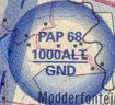
| Which of those map snippets show an airspace that you are not allowed to fly in | |||
| a | PNV | ||
 |
|||
| b | WB | ||
 |
|||
| c | FAP | ||
 |
|||
| d | FAD | ||
 |
|||
Correct Answer ..... c
| With a GPS 12 track memory of 1024 points, and an expected task time to fly for 4 hours, to what value are you going to set the track sample rate? | |||
| a | 30 seconds | ||
| b | 60 seconds | ||
| c | 15 seconds | ||
| d | 5 seconds | ||
Correct Answer ..... c
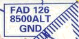
| What does this picture mean ... | |||
 |
|||
| a | Do not fly into it | ||
| b | It is a Notam | ||
| c | Danger Area | ||
| d | It starts from FL 70 | ||
Correct Answer ..... c
| Flying trim speed at 36 km/h. And the wind from the back pushing with 18 km/h. Average sink rate is 1.5m/s. What is your glide ratio? | |||
| a | 5 | ||
| b | 15 | ||
| c | 10 | ||
| d | 7 | ||
Correct Answer ..... c
| Maximum altitude that one can go in SA outside any other restricted areas? | |||
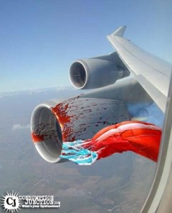 |
|||
| a | FL110 - around 3300 m ASL | ||
| b | FL 145 - about 4500 m ASL | ||
| c | FL195 - about 5900 m ASL | ||
| d | unlimited - the picture shows that a minced pilot does not make any impact on a jet engine | ||
Correct Answer ..... c
| About 20 gliders are ridge soaring when the wind dies and everyone has to go for landing | |||
| a | The gliders to my right have right of way | ||
| b | The faster gliders have right of way | ||
| c | The gliders who are lower than me have right of way | ||
| d | The gliders to my left have right of way | ||
Correct Answer ..... a c
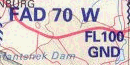
| How high, thumbsuck, can one go AGL here ? | |||
 |
|||
| a | Outside of the JHB TMA, up to 5900 m ASL | ||
| b | Inside the SRA, 700 m max AGL | ||
| c | Under an Airway , about 1800 meters AGL | ||
| d | Still within JHB TMA, 3300 m ASL | ||
Correct Answer ..... c
| A blue hole is | |||
| a | A tear in a paraglider that goes through the top and bottom surface | ||
| b | An aerobatics maneuver | ||
| c | A cloudless area on a thermic day where one expects very few thermals | ||
| d | A task in a competition where no one made goal | ||
Correct Answer ..... c
| A GPS set to GOTO BULWER shows a TRK of 358 and a BRG of 178 | |||
| a | You are South of Bulwer, heading North | ||
| b | You are South of Bulwer, heading South | ||
| c | You are North of Bulwer heading North | ||
| d | You are North of Bulwer, heading South | ||
Correct Answer ..... c
| Santa uses his airmap to navigate around the high Norwegian mountains and to avoid crashing into them... ? | |||
 |
|||
| a | he will be using QNH | ||
| b | he is flying based on Standard Atmosphere | ||
| c | he will be flying QFE | ||
| d | he is on 1013mb | ||
Correct Answer ..... a
| With good thermals ahead and the wind pushing you, according to the Speed to Fly theory, how should one fly | |||
| a | faster than best glide | ||
| b | minimum sink | ||
| c | slower than best glide | ||
| d | best glide | ||
Correct Answer ..... a
| On an Airspace map an FAP means | |||
| a | A Prohibited Area, you can not enter into that airspace at all | ||
| b | A Defense Force Area, you will be used for shooting practice if you fly there | ||
| c | A Danger area, you can fly there, but certain activity, like aerobatics can happen | ||
| d | A Restricted Area, better stay out of it | ||
Correct Answer ..... a
| 25 km/h corresponds to | |||
| a | 45 knots | ||
| b | 6 nautical miles | ||
| c | 13 knots | ||
| d | 3 m/s | ||
Correct Answer ..... c
| This shows a part of AIC 45-1. If your takeoff is 1600 m ASL, how high are you allowed to thermal? | |||
 |
|||
| a | 700 meters above ground | ||
| b | 1700 meters above ground | ||
| c | 545 meters above ground | ||
| d | 2300 meters above ground | ||
Correct Answer ..... c
| Santa zeroes his altimeter inside his grotto... ? | |||
 |
|||
| a | he will be using QNH | ||
| b | he is flying based on Standard Atmosphere | ||
| c | he will be flying QFE | ||
| d | he is on 1013mb | ||
Correct Answer ..... c
| You are 1500 meter AGL. Your average sink is 1m/s. Your GPS reckons that your Ground speed is 36 km/h. Assuming no change, how far will you get? | |||
| a | 30 km | ||
| b | 36 km | ||
| c | 15 km | ||
| d | 20 km | ||
Correct Answer ..... c
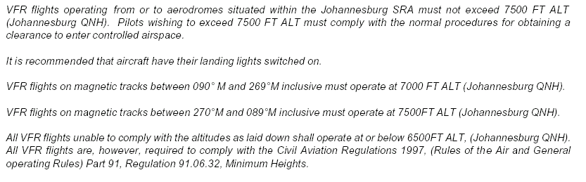
| To get the correct QNH when flying under the JHB TMA one can | |||
| a | Listen to the radio comms of aicrafts who fly under the TMA which QNH they use | ||
| b | Listen on an airband receiver to the JHB tower | ||
| c | make sure you Vario shows 1013 on your reference pressure setting | ||
| d | Zero the A2 on a Vario and not go higher than 700m | ||
| e | set your Vario to show 1600 m altitude at a site which is 1600m ASL and not go higher than 2300m | ||
Correct Answer ..... a b d e
| Xmas Bonus Question: Santa takes off at sea level with his altimeter zeroed and at half the speed of light flies to another sea-level site, hundreds of miles away. His altimeter is now displaying 400m. Did Santa fly into lower or higher pressure? | |||
 |
|||
| a | Santa flew into higher pressure | ||
| b | His altimeter is faulty | ||
| c | Santa flew into lower pressure | ||
| d | Pressure is not linked with altitude | ||
Correct Answer ..... c
| Flying trimspeed into wind your GPS shows 16 km/h and when you turn downwind you got 60 km/h | |||
| a | The wind speed is 26 km/h | ||
| b | One can not determine the wind speed with this info | ||
| c | The wind speed is 22 km/h | ||
| d | The wind speed is 24 km/h | ||
Correct Answer ..... c
| What does this picture mean ... | |||
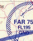 |
|||
| a | You can fly into it | ||
| b | It is a Notam | ||
| c | Restricted Area | ||
| d | It starts from FL 75 | ||
Correct Answer ..... c
| A pilot has set his GPS on GOTO TAKEOFF and reports the heading of his Track TRK as 90 | |||
| a | He is to the East of takeoff | ||
| b | He is flying in a Westerly direction and can be anywhere | ||
| c | He is to the West of takeoff | ||
| d | He is flying in an easterly direction, could be anywhere | ||
Correct Answer ..... d
| Setting your Vario to QFE means ... | |||
| a | You will get the altitude above sea level displayed | ||
| b | You switch off the sink alarm, Quiet Flying Environment | ||
| c | A2 has been set to zero and you will then get the AGL altitude displayed | ||
| d | It will show the altitude in relation to 1013.25mb reference standard atmosphere | ||
Correct Answer ..... c
| You plan to winch off the XYZ airfield. The main tar runway says 07 at one end. The wind is Northerly. The field got a grass runway on an angle of 100 degree to the main runway. What will you announce on the airband radio when you launch a paraglider, using the most suitable runway into wind? | |||
| a | XYZ Traffic, Paraglider winchlaunched on 33 tar runway | ||
| b | XYZ Traffic, Paraglider winchlaunched on 15 grass runway | ||
| c | XYZ Traffic, Paraglider winchlaunched on 33 tar runway | ||
| d | XYZ Traffic, Paraglider winchlaunched on 25 grass runway | ||
| e | XYZ Traffic, Paraglider winchlaunched on 07 tar runway | ||
| f | XYZ Traffic, Paraglider winchlaunched on 25 tar runway | ||
| g | XYZ Traffic, Paraglider winchlaunched on 33 grass runway | ||
| h | XYZ Traffic, Paraglider winchlaunched on 17 grass runway | ||
| i | XYZ Traffic, Paraglider winchlaunched on 32 grass runway | ||
Correct Answer ..... g
| A US pilot reports that he was going up with a 100 ft per minute | |||
| a | not bad, good 5 m/s thermal | ||
| b | printing mistake, lift is only expressed in m/s | ||
| c | nothing to brag about, 0.5 m/s | ||
| d | he was in a thunderstorm cloud, 20 m/s | ||
Correct Answer ..... c
| The expression Authority to Fly or Permission to Fly | |||
| a | Has been delegated by the SA government to the CAA for administration | ||
| b | CAA has appointed SAHPA to administrate this for Hang Gliding and Paragliding | ||
| c | is based on a law that no person or man made object is allowed to fly in South Africa unless one gets permission from the government | ||
| d | CAA has appointed the Aero Club of SA to administrate this for Hang Gliding and Paragliding | ||
Correct Answer ..... a c d
| What does this picture mean ... | |||
 |
|||
| a | You can fly into it | ||
| b | It is a Notam | ||
| c | Prohibited Area | ||
| d | It starts from FL 80 | ||
Correct Answer ..... c
| To get out of cloudsuck | |||
| a | Fly downwind, with the wind | ||
| b | Stay where you are and turn, it will stop | ||
| c | Fly sideways in relation to the main wind direction | ||
| d | Fly upwind, into wind | ||
Correct Answer ..... c
| A pilot has send his landing coordinates via SMS to you. You pinpoint his position on a 1:500.000 ICAO map. It is about 5cm away from your position. | |||
| a | He is about 2.5 km away from you | ||
| b | He is about 10 km away from you | ||
| c | He is about 25 km away from you | ||
| d | He is about 50 km away from you | ||
Correct Answer ..... c
| One should always try to land | |||
| a | With the wind | ||
| b | in no wind | ||
| c | into Wind | ||
| d | cross Wind | ||
Correct Answer ..... c
| A Magnetic compass used SW of Kuruman at Sishen a big iron ore mine | |||
| a | Will show true North | ||
| b | will work ok, once left for half an hour undisturbed before takeoff to adjust | ||
| c | Will deviate quite severe from true North | ||
| d | will not work at all | ||
Correct Answer ..... c
| Your GPS has gone flat. You are heading along a road at 16.00 with the sun behind you | |||
| a | You are flying in a Westerly direction | ||
| b | You are floying in a Southerly direction | ||
| c | You flying in an Easterly Direction | ||
| d | You are flying in a Northerly direction | ||
Correct Answer ..... c
| 1 nautical mile corresponds to | |||
| a | 1 minute at the equator | ||
| b | 60 km | ||
| c | 1.852 km | ||
| d | 111 km | ||
Correct Answer ..... a c
| the end points of the earth axis are called | |||
| a | Nadir and Zenith | ||
| b | Ursa minor and Ursa major | ||
| c | geographic North and South pole | ||
| d | magnetic North and South pole | ||
Correct Answer ..... c
| 1 degree at the equator corresponds to | |||
| a | 111 km | ||
| b | 60 minutes | ||
| c | 60 nautical miles | ||
| d | 273 degree Kelvin | ||
Correct Answer ..... a b c