
Build yourself a simple weatherstation , examples are here


Once you got this to work and understand it, you are ready for the next steps
For the next steps you require Internet access.
What you probably got, since you are reading this web page.
For South Africa, to get some idea what will happen the next few days one can use WindGuru
http://www.windguru.cz/int/index.php?lang=eng

WindGuru tends to be too optimistic on the wind speed. Double what they forecast to cater for the worst case gusts.
Or one can use http://www.myweather.co.za/forecasts.html to get an idea what might happen in future.

Example of the rain forecast by myWeather

So you want to know if this will be a flyable day>
Start with using the Spot Graph.
http://old.weathersa.co.za/Aerosport/graphsNEWMODEL.jsp

Select a Spot closest to you

The first image in the Spot graph gives Wind direction and speed, plus some idea how much cloud or rain we might get.
Lots of green is bad = lots of rain.

Wind Direction - If you plan to fly from a hill then you need the wind to come up the front face of you take off.
So check if the wind direction is suitale. You have to know what direction you takeoff is facing.
Like Rustenburg would be W/NW. Or Bambi is S,E,NE. Or Barberton is NW,N,NE.
In the spotgraph the line is showing from where they reckon the wild will come.
(Opposite of what the windsock would do ).
Wind Speed - the small or bgger ticks are wind speed. small is 5kt, big is 10kt. For a nice day you need a small or a big one. But not more.
If there is a small tick on the ground, and the next higher up level lines got lots of ticks , then we got stronger wind higher up
And the higher wind tends to come down.... making it a blown out day => no fly.
Compare the forecasts from the Spot Graph and/or WindGuru windspeeds with the actuals either by finding a weather station closest tovyour flyingsite.
http://iweathar.co.za//stations.php

or use a METAR report from an airfield
http://aviation.weathersa.co.za/aviation/metars.php?type=metar&view=nw

Gauteng
FAJS 021130Z 31017KT 9999 FEW025 23/15 Q1018 NOSIG=
FAWK 021100Z 32010KT 9999 SCT025 23/// Q1020=
FAJB 021100Z AUTO 31004KT //// // ////// 24/16 Q1018=
FALA 021100Z 33013KT 9999 SCT060 25/18 Q1017=
FAWB 021100Z 33009G14KT 9999 SCT030 27/17 Q1015=
FAPR 021100Z 02007KT 9999 BKN040 21/12 Q1016=
FAIR 021100Z 31010KT 9999 BKN025 23/16 Q1018=
FASI 021100Z AUTO 29010KT //// // ////// 25/18 Q1017=
FAGC 021100Z AUTO 32009KT //// // ////// 22/15 Q1019=
FAGM 021100Z 35016KT 9999 FEW020 23/15 1018=
FAVV 021100Z AUTO 31012KT //// // ////// 26/15 Q1015=
In this case FAJS ( JHB OR Tambo) got a 17kt wind.
kt = knots = is roughly 2x km/h . In this case 17kt is about 30km/h+ = too strong for a comfortable flight.
In most cases WindGuru is too optimistic and tends to give us less wind speed , compared to what really happens.
The next image in the spot graph gives an expected thermal strenght and some cloud amount and height info.

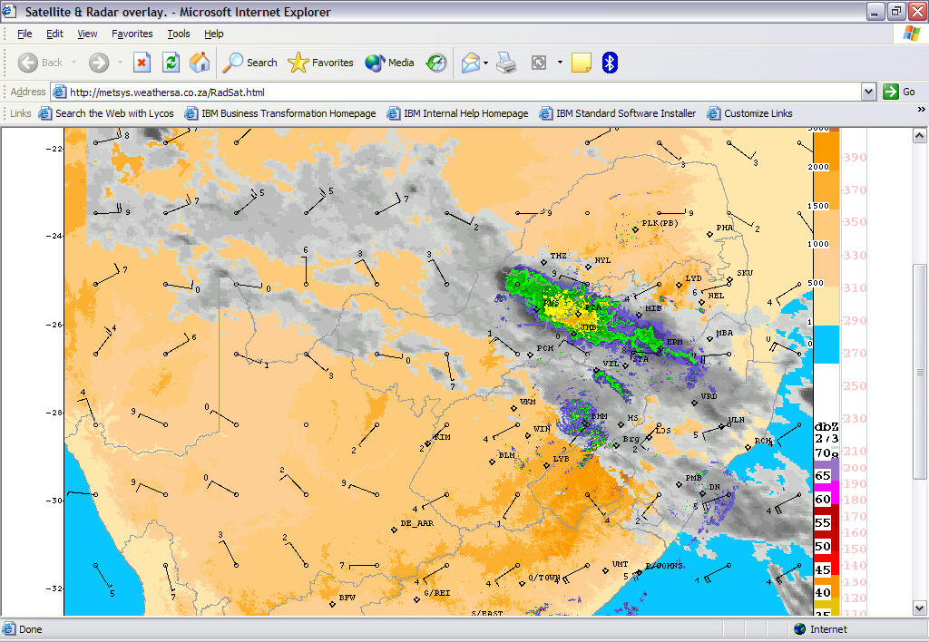
Check the weather radar for any cloud moving in, what will kill the thermals.
Or any thunderstorms building up , what will make it dangerous to fly.
http://metsys.weathersa.co.za/RadSat.html

And check for thunderstorm potential on AeroSport
http://old.weathersa.co.za/Aerosport/ThunderstormsNEWMODEL.jsp


http://wap2.windguru.cz/view.php?username=deviljf&password=jfdevil1&sc=60626&m=3&n=&start=-4&full=1
and replace the number 60626 with the site number below
Harties - 60626
Eagles - 158856
Langberg - 104102
Leopards Rock - 153059
Wigwam - 153062
Porterville - 164315
Bronkies - 78631
Bambi - 60872
Barberton - 60875
Bulwer - 61520
De Aar - 73873
Dumbe - 127040
Dunnothar - 74260
Ngwodwana -160072
Vaalkop - 60879
Thabazimbi - 60724
Monks Cowl - 191886
Amatava - 197554
Maanhaarrand – 194713
Koppies Dam - 160591
http://stpxml.sourceforge.net/skygod/Weather/Weather.html
http://stpxml.sourceforge.net/skygod/Weather/Sounding.html
http://stpxml.sourceforge.net/skygod/Weather/NOAA/NOAA_SOUNDING.html
http://www.xcskies.com/ for soaring forecasts = fee based
http://old.weathersa.co.za/Aerosport/Aerosport.jsp Aero Sport weather website
http://aviation.weathersa.co.za one has to register