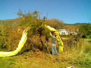
Barberton Lone Tree Hill
Use 124.8 for Airband
http://www.arl.noaa.gov/ready2-bin/main.pl?Lat=-25.80&Lon=31.05
http://old.weathersa.co.za/Aerosport/ShowSpotGraphNEWMODEL.jsp?img=-2631
2010 Barberton Rules
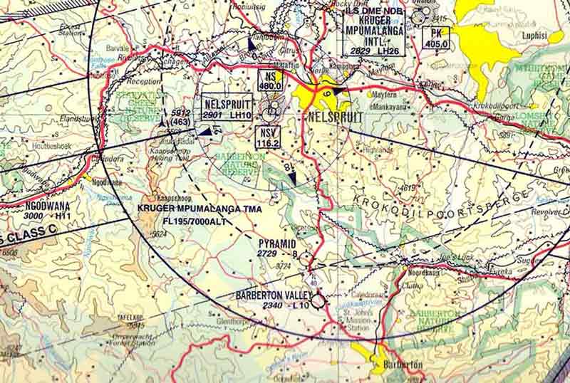
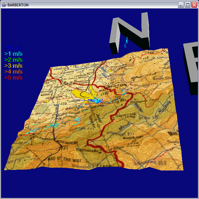
Aviation chart showing the Barberton Valley Airfield.
Please note that base turns to final approach RWY 35 is over the Badplaas road south of the airfield. Larger turbine aircraft turn base up to 4nm south of the Airfield and departures are south bound on runway heading 170 up to 5nm prior to turn out onto track. Barberton Valley Tower is on freq. 120.2 Explosives and aerial pyrotechnics for Airshow and Film /TV Special Effects get tested next to the runway. Due to this hazard all aircraft approaching, joining or flying overhead or abeam the airfield are requested to contact "Barberton Valley Airfield" on freq: 124.8
Google Earth Lone Tree Hill Takeoff behind
For weather use NOAA http://www.arl.noaa.gov/ready2-bin/main.pl?Lat=-25.60&Lon=31.05
Weather radar http://metsys.weathersa.co.za/SZ.html
Thermals and trigger points along the spurs
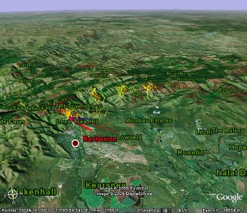
Picture created with http://earth.google.com and the KMZ file showing all the thermals was produced with T3D2
More Thermals from 2006 comp Task1 Task2 Task3 Task4 Task5 Task6
2009 Barberton comp thermals
Getting high over
FORWARD TO ALL YOUR CLUB
MEMBERS PLEASE
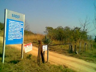
Martin van Rensburg, the Plantation Manager, Barberton Sappi has issued an
urgent request for ALL Paragliding
pilots to please adhere to the existing
rules of entry by obtaining a permit
and a key before going up to take-off.
Failure to do so will
result in site closure.
Sappi as landowners have common law
rights which include the right to deny
us access to their property. Any
member of SAHPA found contravening SAPPI
rules and regulations will be brought
into a disciplinary hearing which will
include SAHPA license withdrawal.
Martin van Rensburg has found pilots with no permits on the site and
issued
SAHPA with a warning of
permanent closure should this trend continue.
The boom-gate is
currently left open to facilitate timber extraction ONLY,
do not take advantage of this.
Forest guards will be patrolling the site to
check permits.
Please, treat this site
with respect, be responsible, think beyond yourself,
we cannot afford to lose this site.
-------------------------------------------------
Tracey King
SAHPA Communication
Barberton
Check with Martin van Rensburg 013 7123591 if the site can be used. It might be closed due to fire hazard or logging activity.
If the Fire Danger Index forecast is above 60 in the orange, no entrance is allowed.
A winter flying site. Tends to be too wet and humid with to many thunderstorms in the summer months.
500m height difference from takeoff at Lone Tree hill to landing in the Golf course.
Basic , easy takeoff on a grass slope facing NE, N, NW
Landing on golf course one pays a daily green
fee to the caddy master .
Before planning to fly, first check with golf course if
it is ok to use the premises and the drive ways for landing for the day.
Or if they run some major golf event. If
there is an event, arrange with golf course which areas can be used.
Like the "usual" overgrown landing area below the putting area.
One can claim lots of trees in
Access road is owned by a forest company. About 30 minutes one way to get to take off.
Arrange for lift clubs to get to the top.
The forestry might have a limit on the amount of vehicles which can be
parked behind take-off.
The site might be closed due to fire hazard.
No smoking at all on take-off.
One requires a permit and a key to use the road to take-off.
Which can be obtained from the Highveld
security company.
There is a limit to the number of keys and permits.
Find out from local pilots where the security office is located.
The site can be used based on the landowners
conditions, Sappi, that one is a SAHPA member and
have a 3rd party coverage.
SAPPI is very concerned about the firehazard and
prefers to keep any public away from their assets.
Please ensure that no public goes up and make sure the gate stays locked.
And no one starts an open fire.
The site is also under threat by airspace expansion from the new KMP
airport.

Where to fly
Lone Tree Hill
Get permit first, have someone take down your car.
Or 1 hour walk back to the top to fetch it
Thermals collected during the 2004 PG Nationals.
Picture created with T3D2
Alternatives
Lone Tree Hill faces NE,N,NW
If the wind is S, over the back, when a cold front comes through, go to Vaalkop or Mt Carmel, Or fly Gods Window
Where to eat and drink
Coco Pan, simple meals and breakfast. Their Fettucini Alfredo works very well as a carbo loader for a next day long flight.
Pappas Pizza , maybe open
Wimpy next to Pick'n Pay
And the famous
Carbo load with ready meal pasta from the PicknPay.
The Rock and John Henry's Pub ... to meet the locals.
What else to do
Agnes mine tours, and gold panning, arrange via tourism office.
http://www.mpumalangahappenings.co.za/barberton_homepage.htm#goldstrike
Do the Tunnel walk . Starts
at the playground area , where the old cable way
crosses the road.
Or hike up to take off , or walk down it the task is cancelled.
Slippery, loose rock gravel path.
Day trip to Kruger Park , leave early, 70k to closest gate.
Take passport and go to Maputo , 3 hours to get there?
Local museum 2 hours.
Kill 2-3 hours and Walk up Limers Creek , enjoy the butterflies on the way, maybe gold pan on the way back in the stream.
Go to Tourism Office and arrange a guided tour of the town center.
Drive up Bulembu road, and do a 4 hour round trip via Msauli to Badplass and back to Barberton
http://home.intekom.com/ecotravel/Guides/Reserves/KNP/Kruger_National_Park_Barberton.htm
Continuing up the R40 tar you will notice scars in the mountainside left by earlier mining exploits. Where the tar ends, the traveller in search of spectacular scenery can travel onwards. The more wary can return back down the R40 to Barberton, for the short drive up will already satisfy the eye in terms of the vistas and scenery experienced.
Where the tar ends, its worth your while to turn left onto the Shiaylongubo Dam road and travel 6,8 km down to Peglars bush. This magnificent natural forest in the middle of the pine plantations is an experience not to be missed. The canopy closes over the road in several places and extends for +\- 1 km along the route. It is a short detour but worth it.
Back on the R40 south heading towards Bulembo you encounter the Town Dam situated at the Highlands Forestry offices. It supplies water via a tunnel through the Saddle Back Mountains to the town. The dam is off limit, for it is located amongst the SAPPI pine forests. About 7,5 km up from the dam, the Arial Cableway between Barberton and Bulembu crosses the road. This is an excellent place to get out and watch the cable cars traversing the mountainside. You can literally grab onto them and catch a ride (not recommended).
Carrying on from there you will start noticing mountain streams, waterfalls tree ferns and the odd eagle or two as they hunt the mountainland for prey. Most of the roadside is covered with pine plantations, but every so often it clears to give you some magnificent views over the Songimvelo game reserve to the west. You are also likely to encounter some of the local wildlife like baboon vervet monkeys and duiker. But most likely you will encounter the local cattle as the Swazi people who keep them, traverse the mountainsides looking for grazing.
Two kilometres from the Border post, you will encounter a signboard indicating so. Take the turn off to your right and start descending the Msauli valley. This is an exceptionally beautiful area with waterfalls, the Lomati River and the Komati River meandering through it. This is a piece of heaven tucked away in the little known corner of the province, against the Swaziland border. Roughly thirteen kilometres from the R40 turn off you pass through the all but deserted mining town of Msauli. It has a nine-hole golf course, school, club facilities and a trading store. It is not in operation anymore and only skeleton staff, maintain the infrastructure.
The road becomes much wider after the mine and you start entering the local communities of Ekulindeni and Ekwalatini. You also pass the entrance to the Songimvelo Game reserve and the Komati River Lodge. You are now traversing the middleveld with beautiful examples of granite outcrops and kopies. Some of these outcrops have precariously balanced boulders situated at the strangest angles, as if some greater hand had placed them there. The road eventually becomes tar again, and you just follow the road through the Badplaas district until where it meets up with the R38 Badplaas Barberton road. Badplaas is only about two kilometres of to your left and Barberton about 67 km to your right.
Arrange a 4x4 trip to Eureka city and the golden quarry
http://www.barbertontourism.com/4x4trails.htm
http://www.mountainlands.co.za/mininghistory.aspx
Visit the Agnes mine and do some Gold Panning
http://www.barberton.co.za/index.php?option=com_content&task=view&id=953&Itemid=253
Equipped with gumboots, hard hat and lamp, you can explore the originally discovered reef through the legendary Pioneer Mine and experience the Greenstone belt up close and personal.
If you havent been down a mine or done gold panning yet, and would like to try it out, go on a tour through Pioneer Mine and be taught by expert and South African champion Danny Brink on how to pan for that ever elusive yellow stone.
A few years ago, a group of people at Agnes Mine decided to open the Pioneer Mine for underground tours in a mountain range that is 3,5 billion years old.
French Bob (Auguste Robert) discovered the very first gold reef on June 3. 1883 and panned his way towards his own historic destiny. He was born in France in 1871 and joined the rush to Kimberley Diamond fields. He left for Barberton and discovered the Pioneer Mine that was the first area being mined for gold. It was only a year later that Barberton was officially established by the Barber brothers.
Phil Wikberg and Andrea Botha are your official guides at the mine with facts and tales of the early gold rush to Barberton in the 1800s. Mining was primitive and dangerous and it can be clearly seen in the mine. Although working in extreme dangerous circumstances the pioneers continued to seek fortunes and undaunted spirit, endured untold hardships, suffered many disappointments and disasters, but, always encouraged by a sparkle of gold and unexpected triumphs. Listening to your guides you actually feel the spirits of bygone pioneers and closing your eyes you can imagine them digging underground, hanging from ropes always chipping away at the gold specs that could clearly be seen.
The geology of the area is also quite amazing and many different rocks are shown to the visitor. The greenstone belt is clearly visible at a number or areas in the mine as well as volcanic rock.
After this truly amazing experience you team up with Danny at the same spot where many pioneers panned for gold. This excursion can yield a wealth of fine gold and even for the more patient, a gold nugget.
Underground mine tours for an hour at Tiger Trap will cost you R80 per person. For two hours you can do the Beaver, Tiger Trap tour at a cost of R70 per person or a three hour trip through Pioneer, Beaver and Tiger Trap at R180 per person.
Gold panning can be done for R80.
A combined tour and panning can be done between R150 to R220 per person. There are also concession prizes for pensioner over 65, students with a valid student card, scholars under 16 years and large tour of family groups. Toddlers five years or younger are free.
For more information contact Phil on 084-580-2845 or Andrea on 079-180-1488 or Danny on 082-482-1803.
Emergencies
Drag your body into the
They can handle stitches but nothing serious.
More serious injuries have to be handled by the Nelspruit private hospital.
No dedicated rescue helicopter close by.
Best is a ride in the back of a police chopper dispatched from Nelspruit.
Needs about 3-4 hours to get it approved to take care
of your emergency.
Area behind takeoff is very bad for any easy access.
Best crash over town , close to Eureka hospital.
Where to stay in Barberton
Veldschool
Barberton Environmental Centre EEC OOS 013 712 3109
or 3193, benviro@telkomsa.net
Camp Ground
Bed+Breakfast places
List of places to stay BarbertonAccommo.doc
Hotels
---------
Rooms
Diggers
50 People
Self Catering, Cottages And Chalets
------------------------------------------------
Barberton Chalets and Caravan Park General Street +27 (13) 7123323
walmec@soft.co.za 114 People
Diggers Rest Sheba Road +27 (13) 7122995 20 People
Fountain Baths* Pilgrim Street +27 (13) 7122707 fountainbaths@hotmail.com
17 People
Gracefarm Cottages Badplaas
Road +27 (13) 7125068 8 People
The Balcony Bowness Street +27 (13) 7124847
barbvet@soft.co.za 6 People
The Chill Inn De Villiers Street +27 (13) 7125055
origins@soft.co.za 20
People
Oppikoppie* Henry Nettman
Street +27 (13) 7126498 / 2365
hitech.security@soft.co.za 8 People
Cammilla's Place Sheba Road +27 (13) 7125647 3
People
Barberton Daisy Lodge Nelspruit Road +27 (13)
7122486 15 People
Mountgrove GuestHouse* Moodies Estate +27 (72) 5030910
globalgroups@worlonline.co.za
Makhiwa Guest House Kaapmuiden
Road +27 (82) 5601886
marlizebo@freemail.absa.co.za
JockOfTheBushveldHuts* Nelspruit
Road +27 (13) 7124002 thatchers@soft.co.za
44 People
Queen Rose Hiking Trail Badplaas Road +27 (13)
7126054
The Hide Out General Street +27 (82) 9664941 reggieval@ncomglobal.com 12
People
* Breakfast on request
Bed And Breakfast
--------------------------
Kloof House Kloof Street
+27 (13) 7124268 kloofhuis@xsinet.co.za 7 People
Engonini B&B Kaapmuiden
Lows Creek +27 (13) 7190019 10 People
Jerusalemskop GameLdg
Nelspruit Road +27 (13) 7125224 10 People
William George House Bok Street +27 (13) 7125886
wilgohouse@telkomsa.net 14
People
Guthries Place Andrews Street +27 (13) 7124072
6 People
Zebra Adv/Trav/Accom Nelspruit
Road +27 (13) 7125408 4 People
* Dinner On Request
Dinner, Bed And Breakfast
--------------------------------------
Old Coach Road Kaapmuiden Road +27 (13) 7199755
oldcoach@global.co.za 28
People
Mazwita Bush Camp
Nelspruit Bush Camp +27 (82) 6041190
Bed, Breakfast And Self-Catering
---------------------------------------------
Barberton Guest House Kaapmuiden Road
People
Tormar Ranch Nelspruit
Road
Sites 40 P
Dinner, Bed, Breakfast and Self-Catering
-------------------------------------------------------
Mantongomane Lodge Rouxville
Farm +27 (13) 7126101 renee@mantongomane.co.za
40 People
Mountainlands Teambuilding & Conference Centre Mountainlands +27
(13)
7127579 +27 (82) 4525664 jand@tiscali.co.za 20 People
Bed Only
-------------
The
Makhonjwa Guest House Duncan Street
Barberton High School Sheba Road
Caravanning And Camping
--------------------------------------
Barberton Chalets and
walmec@soft.co.za 114 People
The lowdown on flying at
-------------------------------------------------
flying capabilities. Watch out for potholes though. Most of us take the road
via
long detour). Others like to go over Machadodorp and Badplaas. The road over
Machadodorp is the best.
We meet on the golf course usually about
your first time there, then we show you the approach plans for landing.
There is a R5 per day landing fee charge, payable on your first landing
there.
All vehicles going up the mountain must have a key which is available from
Hi-Tech security in town. One has to pay R20, and give a deposit of R50. The
key MUST be returned every evening and one gets the deposit back. No cars
without a key is allowed up the mountain. We try and share transport as
much
as possible - just makes it easier at the end of the day. Don't let
sightseers up - it could cost us the site.
No smoking in the vehicle while driving up. Smoking on top
only in the lapa
area.
Accident Report ...
Date
Pilot Ulf Arndt
around 860 flights and about 330 hours
Crash Location
Glider F2F INCA with comp-lines, Harness Apco
Contour and Airbag
Lauched 14.00 from Lone Tree into 20-25km/h wind straight up from the North.
Easy thermal 2-3 m/s with quite a drift indicating some Easterly component.
At 800 m ATO decided to head for the start tarp towards Bulembu road.
Noticed that other gliders battled to stay up when going direct to tarp.
Sinking out into the gullies.
Decided to follow the ridge contour. To make use of any ridge lift or thermals
and work my way towards tarp.
Did not find much lift but encountered an increasing NE headwind.
Over the highest peak , about 200m above ground, I hardly penetrated with trims
off and speed bar applied heading NE.
Decided to try to get down before the ridge into gully.
Should have run over the back and landed in the next valley.
Applied full speedbar, trims off, standing/hanging on
the risers.
Tried to tuck ears, got some lines mixed up, one side was 2 lines tucked, other
side was 1 line.
Sank below ridge , about 50 m in front.
Glider started to drift right sideways into the rock face due to non
symmetric big ears..
Stopped big ears, and applied B-Line stall while going backwards and over the
crest.
1 meter above ground let go B lines and tried C line collapse, but messed it
up, grabbing on one side C and the other probably D riser.
Should have stayed on trims off and speedbar and
focus on getting Cs at the right moment.
Glider flipped around ,I got swung around , facing into drag
direction. giving me a big jump, then leading edge at the ground.
Glider stayed inflated, and dragged me through the rocks.
While swinging around , right leg got caught on a rock and broke.
Got picked up,made a 5?m jump,leaning
back with body, trying to get legs out of the way , facing into drag direction
and used airbag , Apco Contour with foam and thin kevlar plate and side protectors, to take the next impacts.
Then I somehow managed to collapse the canopy.
Started rolling sidewards.
Ended up lying on my right hand side.
Broke right femure, cracked some ribs and cracked
left knee cap, and the back had some cracks
( Not aware of that while I was lying there. Only at the hospital the doc
mentioned ... you broke your back again ... ).
Could not move and did not move after I came to a rest. Right leg indicated
either broken femure or pelvis.
Ribs were aching, making it difficult to breath and talk.
Behind the mountain crest, out of direct line of sight with comp organizers.
My radio was mounted to a front chest strap of harness, could undo it.
Could not raise anyone over the radio. Kept transmitting blind my GPS
coordinates in regular intervals on both frequencies using a long (
quarter wave length) aerial. Radio indicated that I was transmitting but never
managed to pick up any other station.
Cell phone in breast pocket, managed to pull it out.
Cell phone reception was intermittent. Showed cell phone coverage but the
moment I dialed showed no service.
But when I left it about 30 cm in front of me signal improved and I managed to
maintain a longer connection.
( That was before SMS was available, nowadays I would SMS my coords )
Did not have Meetdirectors number in the phonebook.
Managed to get through to 082 911, described my situation and gave them my GPS
coordinates.
Manged to get through to Williams Voicemail and left
GPS coordinates.
Laura phoned me later when shock symptoms started.
After 1 hour shock set in, opened my front mounted reserve, wrapped myself into
reserve parachute.
Could get to my whistle in harness in side pocket and whistled SOS in
intervals.
After 1.5 hours first fellow pilot ( Jonathan ) arrived.
Around 17.00 police helicopter from Nelspruit
was given the go ahead, which arrived at sunset (17.30?). Helicopter managed to
land 25m? next to me.
Got scooped up and put into helicopter , taking off in darkness to Nelspruit airfield.
Chopper was a normal police B109. Means one is sliding around in the back cargo
area.
Not equipped for 1st aid rescue missions.
Around 18.30 at Nelspruit Mediclinic.
Due to some other emergencies ( rallye
driver bleeding to death ) got operated midnigth
until 3.00.
Got now another pin and plate and some more screws in my right leg. ( More
weight on the right side and my thermal turn preference is anyways right)
Can recommend Nelspruit Mediclinic
in future .
Discharged with some more pins and plates and screws in the right femur 19/6
early morning after a quick check if I can handle the crutches.
But there was no transport to get me from Nelspruit
back home.
Got a lift a day later to get back home.
What went wrong, what worked ok?
- Not having a proper Plan B and too much in competition mode. Aiming to get
to Starttarp and ignoring the warning signs of the
wind picking up
- Trying too many different sink approaches. Should have settled for trims off,
speed bar and Cs. Worked for me before in similar circumstances.
- Providing GPS coordinates enabled rescue team to locate me quickly. Without
the GPS info I would probably not have been located until the next day.
And the others figuring out my GPS coordinates ( which got garbled ) and
applying them.
- Having a good harness , airbag, Hanwag boots,...
taking a lot of the impacts , protecting me
- I could only use what was in reach.
Cell phone in breast pocket. No good to have it
in a side pocket of a harness or in the backpack and one can not reach it
Vario and GPS came loose
from front mount reserve velcro but had extra elastic
straps attached, and could be used afterwards.
Vario and GPS had both extra
protective covers, otherwise they would not have been smashed up.
- Assume Netcare was not aware of the competition.
Had no idea who to contact to cross check.
In future I recommend that comp organizers
inform ( can be done via SAHPA ) Netcare that there
is a comp in a certain area
- Not having the meet directors number in the cell phone. Could have avoided
some confusion.