South Africa
by Ulf Arndt, 2008
This write-up is intended to give tips specific for

Most weather books available for Hang Gliding and Paragliding pilots
in
And cover an area which is influenced by a mix of warm and cold fronts.
This type of weather we tend to get in
Otherwise the flying weather is driven by the fact that the
And the
The overseas books are still good to provide you with the basics. Like
Dennis Pagen, Understanding the Sky. And there is one local written book, which
is a bit over the top for most of us, called The Atmosphere and
Weather of Southern Africa by Preston-Whyte and Tyson for anyone who wants to
get a good understanding on the local weather.
Summer and Winter in South Africa
Winter Weather
Western Cape
----- Original Message
-----
To:
<cahgc@smartgroups.com>
Sent:
Subject: [cahgc] Beware
the FOG
> Just another winter
notice.
>
> We had a bit of a
incident the past weekend, when on saterday morning I arrived at Rondebossie it
was nice and clear with fog on the coast.
> Winds where light
and the paragliders where training so I sat around watching them and
microlights and ultralights enjoying the morning air.
>
> Then suddenly the
whole of the cape and the flats was covered in FOG, it happened at a
astonishing rate, easily 5 minutes flat from great vis
> over the whole area
to no ground in sight, this must have created havoc for the microlight
pilots as they where seen flying around circling the hill, I was already
thinking of clearing the hill to make a landing spot for these guys.
>
> But the fog slowly
started to burn of after about a hour, and these guys could land. I bet some of
them where low on fuel by then!!!
>
> So beware, FOG can
really mess up your flying...
>
> FOG - F**k Oll
Ground.
>
> Have fun out
there...
A high-pressure system moves northward bringing
Cloudiness and rainfall are normally restricted to this region and
south-eastern coasts, as a result of cyclonic or frontal type ,.
Highveld
A separate cell of high pressure is situated over this area
during winter. This result in clear skies and calm conditions. Snowfalls occur
along the escarpment and more rarely, over the interior.
Interior snowfalls are usually associated with the presence of a strong high
following closely behind a cold front (thus “pushing” the cold air into the
interior from the east), as well as a strong upper air low which enables
uplift, condensation and cloud formation to take place although orographic uplift
(mountain lift) is important along the escarpment.
Summer Weather Conditions
Western Cape
The
The Atlantic high , which has its center near the west coast of
Highveld
The Indian high has its center well out to sea. The winds
that originate from this high travel across the warm
Where the air from the Indian high meets the air from the Atlantic high a so-called moisture boundary (sometimes referred to a moisture front) occurs. The Atlantic air undercuts the Indian air, causing uplift, condensation and cloud formation.
The position of this boundary often effects the distribution of rainfall
over the whole Highveld region. When it lies to the north, drought
conditions prevail, when to the south, widespread rains are possible. Easterly,
north-easterly to northerly winds tend to prevail in this region.
Where do we find the weather we are looking for ...
The good flying in the
In summertime the trough is somewhere over the
If we go too far to the humid area, then one gets too many thunderstorms.
Too far towards the dry air, and nothing works. Why , that air comes
from the
One has to find the right mix between those two airmasses, with some moisture to get the good thermals with the high cloud base.
The Netfor website www.netfor.co.za indicate the trough axis on good days.
See also The Magic of
the Trough Line
With the seasons the trough axis and the permanent high pressure zone fluctuates.
In the SA summer, the desert climate wanders more to
In winter the high pressure belt moves towards the equator and is located over
To have all year good flying one has to follow the trough axis. In summer it
can be located over the
And in Winter someone will have to find it one day in the Limpopo Zimbabwe
area. Up to now no one has been looking for there yet.
And the area which are normally too wet in summer, like the Lowfeld Ngodwana
Barberton area can provide good flying in winter.
Dusties, Whirlys and why is it so rough in spring in the Highveld ...
June, July, August ,Winter in SA, in the
Highveld can be rather boring flying. Thermals start late, let's say 14.00
onwards and close down after 15.00
And then comes September and October and the conditions suddenly become rough,
with dusties and whirlies lurking everywhere. And once the first rains set in
the air becomes smooth and the thermals become softer. Why ...?
My explanation .. Winter means that there has been no rain for a long
time. The ground is dry.
The ground still got time to cool down a lot over night with no clouds
holding back any radiation over night.
In the morning we got a strong inversion, cooled down air close to the ground.
During the day the sun rays warm up the ground.
Typical whirly days have something like 6 degree Celsius in the morning and
close to 30 or more degrees maximum temperature during the day.
And that warmed up air sticks to the ground for a while until it releases with
a vengeance.
Once we get some rain, the ground got some humidity / water on the top. Now the
sun's energy gets used up first to make vapor.
The dew droplets on the grass in the morning "suck" up energy
when they get converted to vapor.
The energy of the sun rays does not heat up the ground and the air close to the
ground so much anymore. The droplets "steal" some of the energy.
Now vapor is H2O molecules which are lighter than N2 or O2 molecules. H2O
got a molecule weight of 10 ( 2x1 + 8) while N2 is 14 and O2 is 16.
The lighter H2O Vapor get pushed up by the heavier N2 and O2 mix , rise
and start releasing thermals easier.
as they go up they take some surrounding air with them that got a bit
warmed up.
The air does not get warmed up for so long anymore before it releases. The
thermals pop more often and are less violent.
As a PG or HG pilot consider the time before the rains start in the Highveld as
the most dangerous season to fly.
Or in layman terms...
If there is no dew on the grass in the morning in September or October in
the Highveld, expect whirlys.
More on thermals see http://www.elltel.net/peterandlinda/thermal_physics.htm
Aware of 3 incidents where pilots got picked up from the ground by whirlies.
- Pilot was about to get into his harness at The Dam. When a whirly came through and lifted his canopy up. Pilot got dragged through the rocks. Hanging upside down , his feet caught in the harness, and his head ( with a helmet) bouncing through the rocks.
- Student pilot was ready to launch at Laudium when a whirly picked him up and dropped, dumped him some meters behind take off
- Pilot was ground handling his canopy on flat ground in Dunnottar. When a whirly cam through, lifted him 10m into the air. Dumped him into the parked vehicles and then dragged him through the adjacent mealie field.
Recommendation - put your helmet on before you climb into the harness.
Use T-Phi Skew-T Diagrams
Sorry,.. what ???
If you have no clue, what this is all about, have a look at the http://stpxml.sourceforge.net/skygod/Weather/Sounding.html document.
Welcome to the world of internet and online information. To get good cross
country flying is about being at the right spot at the right time.
Making the right decisions.
To make the best decisions you better have the right information.
And thanks to the world wide web we now got the information at hand early in
the morning to see if this will be a great cross country flying day.
Only if you are lucky and live close to Irene or another weatherstation that
does a sounding. Close is anything of 100 km to 300 km around that
weatherstation.
Why that range? One can assume that the air does not change much over few 100
km . And if you are downwind of that weatherstation, then you get this air that
they measured at night. For Irene, with a predominant NW wind, and they measure
at 2.00 local time, and a windspeed of 10 km/h , then this air at 12.00 local
time will be 100 km further, roughly around Dunnottar for example.
If you live in the Lowfeld, Kuruman, or PE, .. you can skip that paragraph.
Or try a power pilot to do the sounding for you in the morning.
Gariep and Bitterwasser does it for example , using their own soundings with a
power aircraft.
Or checkout http://stpxml.sourceforge.net/skygod/Weather/NOAA/NOAA_SOUNDING.html
to analyze NOAA data.
SA Weather on the web
Welcome back to those who worked their way through the T-Phi part.
There is another way to figure out if this will be the day of the year.
Use the
http://www.weathersa.co.za/glider/aero.htm which will give you
expected wind and thermal strength.
They seem to get it right for the central
Other links are http://www.weathersa.co.za/
for the SA Weatherbureau.
And http://aviation.weathersa.co.za/
for the flying forecasts.
http://aviation.weathersa.co.za/Regional.htm takes you to
METARS which give you regular updated weatherstation readings from
various airports.
FARG 190600Z AUTO 05001KT //// // //////
03/02 Q1024=
FARG is Rustenburg , done on the 19th of the month, at
06.00 Zulu time , what is 8.00 in the morning
It was done by some automatic device, with the wind 050 ( North
East) and 1 knot
Temperature was 03 degree celcius, dew point was 02 , and
the airpressure was 1024.
Very basic info from
http://www.wunderground.com/
Some crystal ball few days ahead guess from
http://www.csag.uct.ac.za/
Block format
The Aviation website of the SA Weather bureau provides block weather
forecast info.
One can use it to get an idea of the wind and lapse rate.
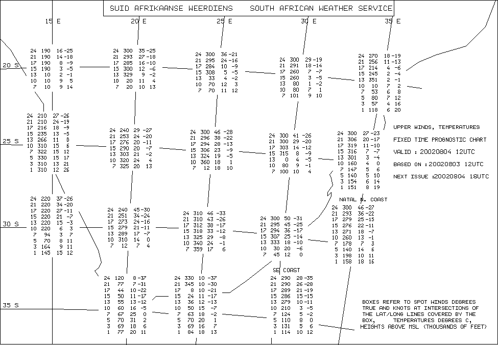
first of all one has to make sure it is valid for the time period that you
plan to fly.
This one says Valid 20020804 12 UTC. Means 14.00 local time.
When we plan to be up in the thermals. They get prepared in 6 hour intervals.
The 6.00 UTC and the 18.00 I only use to see the trend in the wind speed and
direction.
So what do these numbers mean?
First of all you have to figure out where you favorite flying site would be
located on this map.
Map??? What you see there is
And
Let's have a look at the 25/25 intersection.

First column is altitude in 1000's of feet.
Next is the wind direction in degree , 0 is North, 90 would be east, 180
is south, 270 is west, and 360 is again North
Then comes the wind strength in knots, double the value -10 percent
to get km/h
And the last column is a guess on the temperature in degree Celsius.
For our flying we only hover around between 7000 and 10000 feet.
So, only the 2 lowest rows are of interest.
The lowest row means, in 7000 feet ( 2300m ASL) one can
expect a Northerly wind , of 18 knots ( what is 33 km/h ) and 10 degree
One higher up, at 10000 feet, ( 3300m ASL, thumbsuck normally cloudbase)
, Northerly , same 18 knots , and 1 degree.
Ok, so your site is not exactly on one of those grid points. Then you have to interpolate in between. look at the grid points around your site, and average in between those values to get guesstimate of what might happen where you plan to fly.
To get an idea if it will be a good thermal day, have a look at the
temperature difference between the 7000 feet and 10000 feet.
in this example it is 9, what is normal.. Dry adiabatic lapse rate is around
1 degree per 100 meters, Or 3 degree per 1000 feet. Or 9 for 3000 feet.
You can expect average, 2-3 m/s max thermals. If you get a 10 difference, then
get excited, its going to be a very good day.
If you get 8, stay at home.
Synoptic Chart
I use it to get a bit of an idea if we got any fronts approaching or what the wind will do.
Below is an example of a windy, blown out day.
You can see those curves, called isobars, are quite close together over the country. Means you are going to have lots of wind. Not a great flying day.
Here is an example of a day with not much wind from the Aerosport website
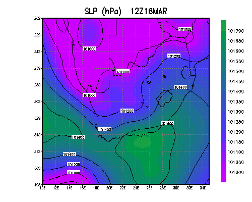
And the same from the CSAG website
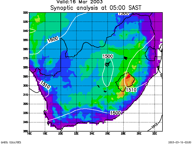
And this was a world record day in De Aar area. 400km PG flight from Vosburg.
Notice the trough, the 2 low pressure systems over the area where the pilots
flew.

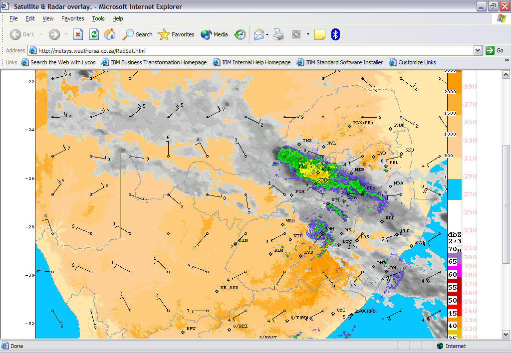
Weather Radar
If it looks lousy where you are, does not mean it is the
same some 200-300 km away.
Use the weather radar off the web to get an idea how big this cloud cover is.
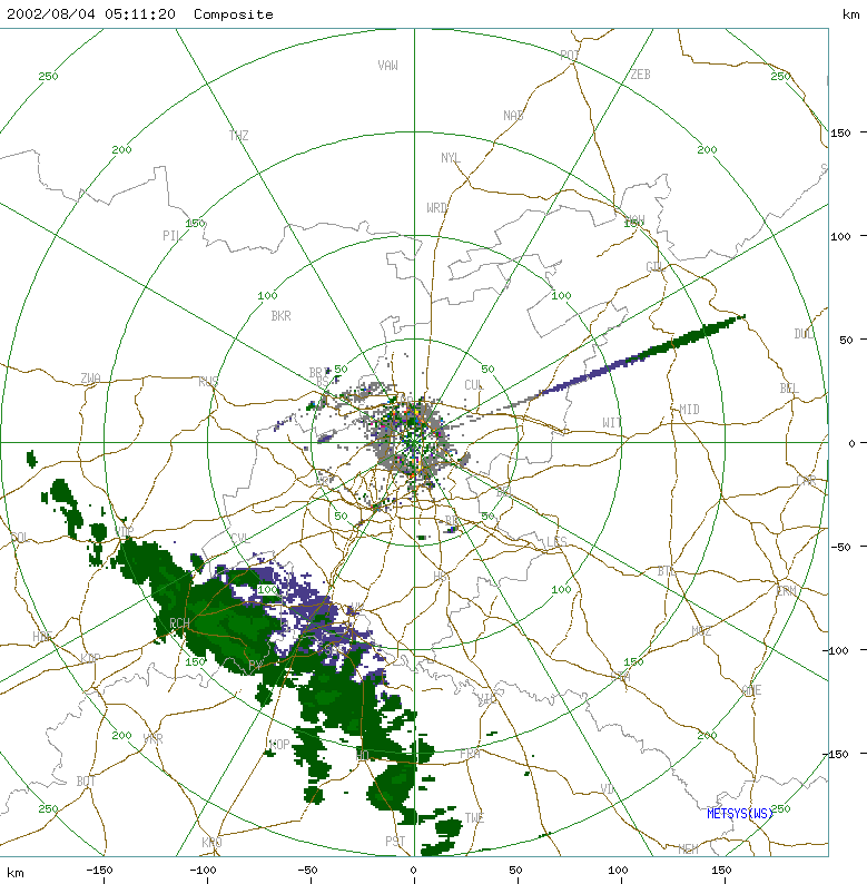
Here you see a front approaching from the south. Not a good idea to go
out to fly the south of
It rains in Joburg, but Welkom is clear
Spot Graphs http://www.weathersa.co.za/Aerosport/Aerosport.jsp
Most popular site with the cross country pilots.
Gives you a quick overview for a certain area of what to expect during the day.
The Dam happens to be right close to one of those dots.
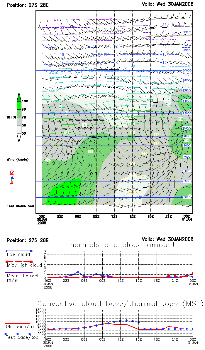
I tend not too rely too much on the thermal forecast. If it correlates with
Soarcast and then I believe it.
But those Spot Graphs diagrams seem to work very well for the Kuruman,
Prieska , De Aar area.
The green color means wet, humid air. Or cloud, fog, rain ....
Thunderstorms
From October until February we can expect daily
thunderstorms in the Highveld Gauteng area.
See also the CAPE value in the Skew-T Diagram.
Stay clear of them, avoid them, get down when they start to develop around you.
How thunderstorms develop and what happens in there is explained at.
http://www.met.tamu.edu/class/Metr304/Severedir/severe-wx-stu.html
http://www.mountainflying.com/mother_nature.htm
The local thunderstorm forecast on the web seem to get it quite right
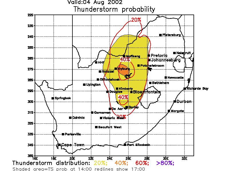
Phoning the Met Office
So you are out in the bundu, and not telephone line or computer to get
onto the Internet?
You can phone the Met Office using 082 233 8800
State that you do Paragliding at whatever place.
And you are interested in what the ground and and the winds up to 10 000 ft will be doing during the day at xyz.
What is the wind doing at the moment?
What will be the expected cloudbase and thermal activity?
Any chance for thunderstorms?
Any frontal systems on their way which will create gust fronts?
Weather Info via the Cell Phone
If you are a Vodacom subscriber then you send a SMS to 4000 with the following text:
weather Welkom (or)
weather JHB (or)
weather jhb tomorrow
ICAO / WMO Cloud continuity scale
Used in the Metar code
· SKC - sky clear, no cloud.
· FEW - few clouds, one to two oktas.
· SCT - scattered, 3 - 4 oktas. Clear intervals between clouds predominate.
· BKN - broken, 5 - 7 oktas. Cloud masses predominate.
· OVC - overcast, 8 oktas. Continuous, no clear intervals.
References, URLs, Weather on the web
Remember "Weather forecasts are horoscopes with numbers."
More info at http://stpxml.sourceforge.net/skygod/ and scroll down to the Weather section.
Some of the Pictures in this document have been copied from the following websites
http://weather.uwyo.edu/upperair/sounding.html
http://www.weathersa.co.za/glider/aero.htm
http://aviation.weathersa.co.za/Regional.htm
http://www.netfor.co.za/gp.htm
http://www.weathersa.co.za/Aerosport/Aerosport.jsp
http://home.att.net/~doug.kathy/Soarcast/Download.htm
http://www.drjack.info/RASP/SW_SOUTHAFRICA/index.html
http://www.arl.noaa.gov/ready/cmet.html
Magic of the trough line http://www.gariepgliding.com/through_line.htm
Weather ABC in German at http://www.dhv.de/typo/Wetter-ABC.221.0.html
Prepared and maintained by Ulf Arndt, Copyright Ulf Arndt 2008
For more info for Paraglider pilots in
